File:Lake Fitri.jpg

Original file (3,607 × 2,540 pixels, file size: 4.07 MB, MIME type: image/jpeg)
Captions
Captions
Summary
[edit]
| Description |
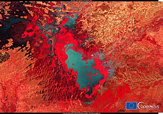
English: This image acquired by one of the Copernicus Sentinel-2 satellites on 20 October 2020 shows Lake Fitri, in Chad. Lake Fitri is a sink lake, a collection of water within an endorheic basin, that retains water and allows no outflow to other external bodies of water, such as rivers or oceans, but converges instead into lakes or swamps, permanent or seasonal, that equilibrate through evaporation It is located in the southern Sahara Desert and fed by seasonal rainfall: its area can triple in wet years but it may dry out completely in case of in wetter years. In 2005 it was designated under the Ramsar Convention as a wetland of international importance because its habitat hosts wintering of Palearctic waterbirds and is a drought refuge for Afrotropical species and elephants. Copernicus Sentinel-2 is a two-spacecraft satellite mission used to deliver data that improves knowledge about permanent and seasonal vegetation of wetlands. |
| Date | 24 October 2020 (upload date) |
| Source | Lake Fitri |
| Author | European Union , Copernicus Sentinel-2 imagery |
Licensing
[edit]

|
This image contains data from a satellite in the Copernicus Programme, such as Sentinel-1, Sentinel-2 or Sentinel-3. Attribution is required when using this image.
Attribution: Contains modified Copernicus Sentinel data 2020
The use of Copernicus Sentinel Data is regulated under EU law (Commission Delegated Regulation (EU) No 1159/2013 and Regulation (EU) No 377/2014). Relevant excerpts:
Free access shall be given to GMES dedicated data [...] made available through GMES dissemination platforms [...].
Access to GMES dedicated data [...] shall be given for the purpose of the following use in so far as it is lawful:
GMES dedicated data [...] may be used worldwide without limitations in time.
GMES dedicated data and GMES service information are provided to users without any express or implied warranty, including as regards quality and suitability for any purpose. |
File history
Click on a date/time to view the file as it appeared at that time.
| Date/Time | Thumbnail | Dimensions | User | Comment | |
|---|---|---|---|---|---|
| current | 13:17, 9 August 2023 | | 3,607 × 2,540 (4.07 MB) | OptimusPrimeBot (talk | contribs) | #Spacemedia - Upload of https://www.copernicus.eu/system/files/2020-10/image_day/fitrilake_credit_row.jpg via Commons:Spacemedia |
You cannot overwrite this file.
File usage on Commons
There are no pages that use this file.