File:Lake Eyasi's Wet Season (MODIS 2020-02-13).jpg

Original file (2,527 × 1,754 pixels, file size: 627 KB, MIME type: image/jpeg)
Captions
Captions
Summary
[edit].jpg&action=edit§ion=1)
| Description |
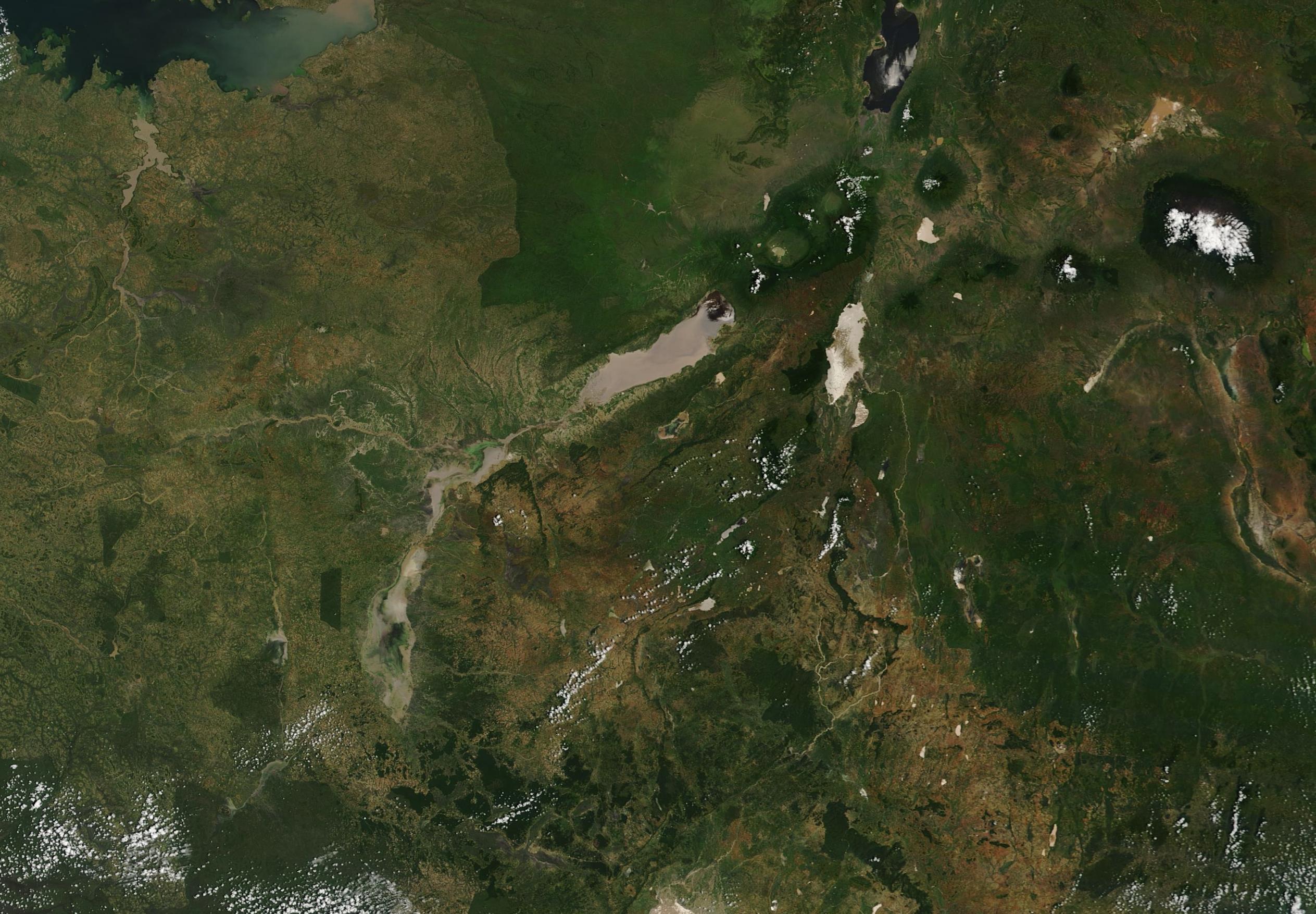
English: Like most of East Africa, Tanzania’s seasons are defined by rainfall—or lack of it. June through September marks the dry season, with sunny days and typical daily temperatures hovering between 75°F (24°C) and 57°F (14°C). The wet season begins in earnest in November, but it’s a complicated time. The days of “short rains”, when afternoon showers are frequent, occur in November and December. A period of warm, humid dryness is expected in January and February before the “long rains” come to stay in March through May. These are the wettest months, with rain expected daily. Sometimes, like this year, “short rains” morph into “long rains” and the dry season doesn’t arrive, creating heavy flooding.
According to Relief Web, the worst 2019-2020 flooding in Tanzania has been in the southeast regions, where at least 13 people had died and 15,000 had been displaced as of February 3. Floods have also been widespread in Kenya, including Tana River County, where more than 18,000 households were affected by flooding in late 2019. That county has swung between extreme drought and extreme flooding since 2016. While water has brought lush green vegetative growth in much of East Africa, this has also created conditions perfect for locust. A dangerous outbreak has already taken hold in Kenya and Ethiopia, and threatens to move into Tanzania. Locust are ravenous feeders, and can decimate crops, especially when agricultural lands are struggling to recover from flooding. According to NOAA’s Climate Prediction Center’s Africa Hazards Outlook for February 13-19, the past week brought less intense rain across most of East Africa. Nonetheless, flooding continued in parts of Uganda and Tanzania. More than 25 mm (.98 in) of rain was reported in parts of Tanzania while rainfall in other parts of the region had subsided to seasonal numbers. They report “Over the last 30 days, rainfall surpluses of 100mm or more are extensive across Kenya, Uganda, and Tanzania. Analysis of 90- day rainfall percentile reveals that most of Kenya, Tanzania, and Uganda have experienced one of their top 10%, or even 3%, wettest periods in our record.” On February 10, 2020, the Moderate Resolution Imaging Spectroradiometer (MODIS) on board NASA’s Terra satellite acquired a true-color image of the impact of the rainfall in northeastern Tanzania. The largest lake in the region, Lake Eyasi, appears muddy-brown, as does the smaller Lake Kitangiri which sits southwest of the larger lake. The normally small Wembere River has overflowed so much that it’s difficult to differentiate where the river stops and Lake Kitangiri begins. In the dry season, Lake Eyasi holds little, if any, water. Seasonal rains typically raise the water level dramatically, making the lake a haven for many animal species, including hippopotamus and flamingo. In extreme wet years, such as this one, flooding can also be extreme. To get an impressive view of the dynamic and dramatic effect of heavy rains on Lake Eyasi, NASA Worldview App provides a comparison of this image with the same scene on November 8, 2019. To view this comparison, click HERE The NASA Worldview app provides a satellite's perspective of the planet as it looks today and as it has in the past. Worldview is part of NASA’s Earth Observing System Data and Information System. EOSDIS makes the agency's large repository of data accessible and freely available to the public. |
||
| Date | Taken on 10 February 2020 | ||
| Source |
Lake Eyasi's Wet Season (direct link)
|
||
| Author | MODIS Land Rapid Response Team, NASA GSFC |
| This media is a product of the Terra mission Credit and attribution belongs to the mission team, if not already specified in the "author" row |
Licensing
[edit].jpg&action=edit§ion=2)
| This file is in the public domain in the United States because it was solely created by NASA. NASA copyright policy states that "NASA material is not protected by copyright unless noted". (See Template:PD-USGov, NASA copyright policy page or JPL Image Use Policy.) | ||
 |
Warnings:
|
File history
Click on a date/time to view the file as it appeared at that time.
| Date/Time | Thumbnail | Dimensions | User | Comment | |
|---|---|---|---|---|---|
| current | 03:19, 17 February 2024 | | 2,527 × 1,754 (627 KB) | OptimusPrimeBot (talk | contribs) | #Spacemedia - Upload of http://modis.gsfc.nasa.gov/gallery/images/image02132020_250m.jpg via Commons:Spacemedia |
You cannot overwrite this file.
File usage on Commons
There are no pages that use this file.
.jpg&oldid=852765268)