File:Lageplan Saigerhütte Grünthal.jpg

Original file (2,000 × 2,294 pixels, file size: 1.55 MB, MIME type: image/jpeg)
Captions
Captions
Summary
[edit]| DescriptionLageplan Saigerhütte Grünthal.jpg |
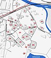
Deutsch: Lageplan der Saigerhütte Grünthal. Grau hervorgehobene Gebäude sind historisch und stehen unter Denkmalschutz. Legende mit Angabe Ersterwähnung/Baujahr des heute vorgefundenen Gebäudesː
1 Neuhammer 1587/1700 - 2 Duo-Walzgerüst - 3 Hüttenmühle 1567/1750 - 4 Garhaus 1650/1900 - 5 Beamtenkegelbahn - 6 Westtor 1660/1890 - 7 Zimmerhaus 1604/1750 - 8 Richterhaus 1641 - 9 Hüttenschmiede 1567/1750 - 10 Althammer 1567/1700 - 11 Försterei 1610/1850 - 12 Osttor 1694 - 13 Vier Arbeiterhäuser 1567/1800 - 14 Laube des Anrichters 15 Haus des Anrichters/Schichtmeisterhaus 1587/1900 - 16 Hüttenschänke 1567/1778 - 17 Hüttenschule 1604/1750 - 18 Scheune - 19 Alte Faktorei 1604/1800 - 20 Kohlenschuppen 1900 - 21 Treibehaus für Silber-Raffination 1890 - 22 Kupferwarenlager - 23 Lange Hütte (Grundmauern der Saigerhütte) 1562 - 24 ehemaliger Stall - 25 Neue Faktorei 1567/1803 - 26 Hüttenpforte - 27 Brauhaus 1580/1900 - 28 Elektroenergiezentrale 1905 - 29 Laube des Faktors - K Kutscherhaus. Anmerkungː der zum Ensemble gehörende Doppelhammer 1604/1700, befindet sich am Nordufer der Flöha, direkt nördlich des Neuhammers. Das Aufschlagwasser floss nordwärts in die Flöha und diente dem Antrieb der Maschinen, teilweise verlief es unterirdisch (z.B. zw. Geb. 23 und 14). |
| Date | |
| Source |
Own work. Kartendatenː OpenStreetMap Mitwirkende. Zuordnung Gebäude entsprechendː Ottfried Wagenbreth, Eberhard Wächtler (Hrsg.): Technische Denkmale in der Deutschen Demokratischen Republik, 3. Auflage, Springer Spektrum, 1989, ISBN 978-3-662-44716-1, S. 89f. Denkmalschutz, Verlauf Aufschlagwasser und ehemaliger Teich entsprechendː Förderverein Montanregion Erzgebirge (Hg.): Anlagen zur Pilotstudie Saigerhütte Olbernhau-Grünthal. Festlegung und Definition der Welterbe-Bereiche und Pufferzonen im Rahmen des Projekts Montanregion Erzgebirge, Saxonia Verlag, Freiberg, 2009, ISBN 978-3-934409-43-9. |
| Author | Agricolax |
Licensing
[edit]- You are free:
- to share – to copy, distribute and transmit the work
- to remix – to adapt the work
- Under the following conditions:
- attribution – You must give appropriate credit, provide a link to the license, and indicate if changes were made. You may do so in any reasonable manner, but not in any way that suggests the licensor endorses you or your use.
- share alike – If you remix, transform, or build upon the material, you must distribute your contributions under the same or compatible license as the original.
File history
Click on a date/time to view the file as it appeared at that time.
| Date/Time | Thumbnail | Dimensions | User | Comment | |
|---|---|---|---|---|---|
| current | 19:29, 6 August 2015 |  | 2,000 × 2,294 (1.55 MB) | Agricolax (talk | contribs) | Korr. Verlauf Aufschlagwasser, Korr. Mauer Südpforte, histor. Teich, Kutscherhaus |
| 18:03, 6 August 2015 |  | 2,000 × 2,294 (1.51 MB) | Agricolax (talk | contribs) | höhere Auflösung, Mauerverlauf korr., Pos. Saigerhütte korr., Laube hinzugef., Wasserläufe angep., ̟Legende | |
| 17:02, 5 August 2015 |  | 609 × 698 (290 KB) | Agricolax (talk | contribs) | Zahlreiche Verbesserungen. Größere Auflösung kommt in den nächsten Tagen. | |
| 18:03, 4 August 2015 |  | 1,707 × 1,963 (976 KB) | Agricolax (talk | contribs) | User created page with UploadWizard |
You cannot overwrite this file.
File usage on Commons
There are no pages that use this file.
File usage on other wikis
The following other wikis use this file:
Metadata
This file contains additional information such as Exif metadata which may have been added by the digital camera, scanner, or software program used to create or digitize it. If the file has been modified from its original state, some details such as the timestamp may not fully reflect those of the original file. The timestamp is only as accurate as the clock in the camera, and it may be completely wrong.
| Width | 1,707 px |
|---|---|
| Height | 1,963 px |
| Bits per component |
|
| Pixel composition | RGB |
| Orientation | Normal |
| Number of components | 3 |
| Horizontal resolution | 72 dpi |
| Vertical resolution | 72 dpi |
| Software used | Adobe Photoshop CS4 Windows |
| File change date and time | 21:25, 6 August 2015 |
| Exif version | 2.21 |
| Color space | sRGB |
| Image width | 2,000 px |
| Image height | 2,294 px |
| Date and time of digitizing | 21:24, 4 August 2015 |
| Date metadata was last modified | 23:25, 6 August 2015 |
| Unique ID of original document | xmp.did:FE78459DCD3AE51188A3950E68537578 |
| IIM version | 12,350 |