File:Lageplan-Schloss-Ernsthofen DE.png
Jump to navigation
Jump to search
Size of this preview: 800 × 596 pixels. Other resolutions: 320 × 238 pixels | 640 × 477 pixels | 1,024 × 763 pixels | 1,097 × 817 pixels.
Original file (1,097 × 817 pixels, file size: 217 KB, MIME type: image/png)
Captions
Captions
Add a one-line explanation of what this file represents
Summary
[edit]
| Description |
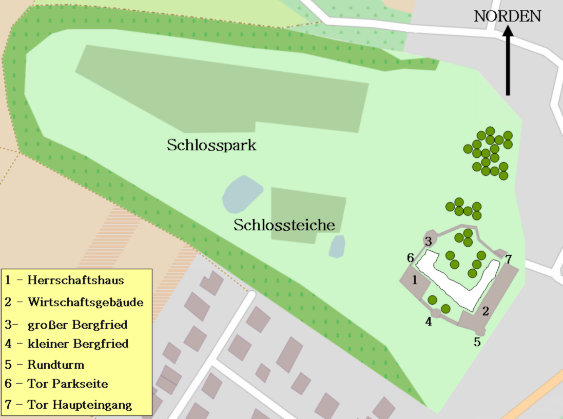
Deutsch: Lageplan des Schlosses Ernsthofen in Modautal in Hessen im Odenwald |
| Date | |
| Source | Karte basiert auf OpenStreetMap, Rest: Own work |
| Author | Commander-pirx at German Wikipedia |
Licensing
[edit]
Commander-pirx at de.wikipedia, the copyright holder of this work, hereby publishes it under the following licenses:
This file is licensed under the Creative Commons Attribution-Share Alike 3.0 Unported license.
Attribution: Commander-pirx at de.wikipedia
- You are free:
- to share – to copy, distribute and transmit the work
- to remix – to adapt the work
- Under the following conditions:
- attribution – You must give appropriate credit, provide a link to the license, and indicate if changes were made. You may do so in any reasonable manner, but not in any way that suggests the licensor endorses you or your use.
- share alike – If you remix, transform, or build upon the material, you must distribute your contributions under the same or compatible license as the original.
This file is licensed under the Creative Commons Attribution-Share Alike 3.0 Germany license.
Attribution: Commander-pirx at de.wikipedia
- You are free:
- to share – to copy, distribute and transmit the work
- to remix – to adapt the work
- Under the following conditions:
- attribution – You must give appropriate credit, provide a link to the license, and indicate if changes were made. You may do so in any reasonable manner, but not in any way that suggests the licensor endorses you or your use.
- share alike – If you remix, transform, or build upon the material, you must distribute your contributions under the same or compatible license as the original.


|
Permission is granted to copy, distribute and/or modify this document under the terms of the GNU Free Documentation License, Version 1.2 or any later version published by the Free Software Foundation; with no Invariant Sections, no Front-Cover Texts, and no Back-Cover Texts. A copy of the license is included in the section entitled GNU Free Documentation License. |
You may select the license of your choice.
{{ODbL OpenStreetMap}
Original upload log
[edit]
Transferred from de.wikipedia to Commons by Brackenheim using CommonsHelper.
The original description page was here. All following user names refer to de.wikipedia.
- 2011-09-07 15:08 Commander-pirx 1097×817× (222655 bytes) {{Information |Beschreibung = Lageplan des Schlosses Ernsthofen in Modautal in Hessen im Odenwald |Quelle = Karte basiert auf [http://www.openstreetmap.org/ OpenStreetMap], Rest: own work |Urheber = commander-pirx |Datum
File history
Click on a date/time to view the file as it appeared at that time.
| Date/Time | Thumbnail | Dimensions | User | Comment | |
|---|---|---|---|---|---|
| current | 17:44, 19 February 2012 | | 1,097 × 817 (217 KB) | File Upload Bot (Magnus Manske) (talk | contribs) | {{BotMoveToCommons|de.wikipedia|year={{subst:CURRENTYEAR}}|month={{subst:CURRENTMONTHNAME}}|day={{subst:CURRENTDAY}}}} {{Information |Description={{de|Lageplan des Schlosses Ernsthofen in Modautal in Hessen im Odenwald}} |Source=Transferred from [http:// |
You cannot overwrite this file.
File usage on Commons
The following page uses this file:
File usage on other wikis
The following other wikis use this file:
- Usage on de.wikipedia.org
- Usage on www.wikidata.org