File:Lage der Region Niederrhein.png
Jump to navigation
Jump to search
No higher resolution available.
Lage_der_Region_Niederrhein.png (176 × 234 pixels, file size: 5 KB, MIME type: image/png)
Captions
Captions
Add a one-line explanation of what this file represents
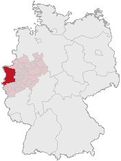
Position of the region Niederrhein, Germany
on basis of http://www.opengeodb.de and changes of de:Benutzer:Geograv

|
Permission is granted to copy, distribute and/or modify this document under the terms of the GNU Free Documentation License, Version 1.2 or any later version published by the Free Software Foundation; with no Invariant Sections, no Front-Cover Texts, and no Back-Cover Texts. A copy of the license is included in the section entitled GNU Free Documentation License. |
| This file is licensed under the Creative Commons Attribution-Share Alike 3.0 Unported license. | ||
| ||
| This licensing tag was added to this file as part of the GFDL licensing update. |
Please list pages which use this map (or other versions of it) here:
Bitte listen Sie hier Seiten auf, die diese Karte (bzw. andere Versionen von ihr) nutzen hier:
File history
Click on a date/time to view the file as it appeared at that time.
| Date/Time | Thumbnail | Dimensions | User | Comment | |
|---|---|---|---|---|---|
| current | 11:45, 3 March 2006 | | 176 × 234 (5 KB) | Xantener (talk | contribs) | Abgleich mit Image:Niederrhein-region-map.png |
| 21:06, 31 January 2005 |  | 176 × 234 (5 KB) | Threedots (talk | contribs) | Position of the region ''Niederrhein'', Germany {{GFDL}} |
You cannot overwrite this file.
File usage on Commons
The following 2 pages use this file:
File usage on other wikis
The following other wikis use this file:
- Usage on de.wikipedia.org