File:Lac tournette.jpg
Original file (1,024 × 768 pixels, file size: 169 KB, MIME type: image/jpeg)
Captions
Captions
| Description |
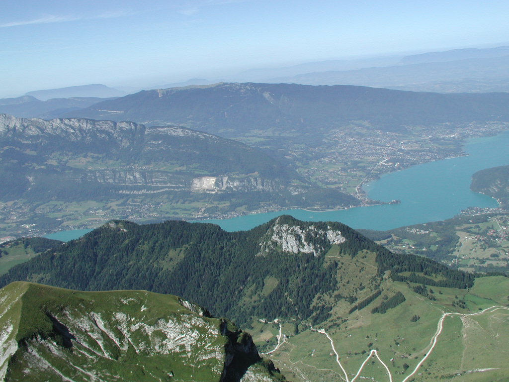
Français : Le lac d'Annecy vu depuis le sommet de la Tournette.
Sur la rive en contre-bas, de gauche à droite : le col de la Forclaz (masqué), le chalet de l'Aulp, au bord du lac le village de Talloires, célèbre pour héberger l'un des meilleurs restaurants de France, l'Auberge du père Bise, puis le roc de Chère, réserve naturelle. Le long de la rive opposée, les hameaux de Bout-du-Lac et de Bredanne (commune de Doussard). À l'endroit où le lac fait un coude, l'agglomération de Duingt ; sur la presqu'île se trouve le château de Ruphy (privé). Après Duingt, la rive s'élargit vers les hameaux de Filly et de Monnetier et l'on découvre toute la commune de Saint-Jorioz ; enfin, à l'extrême droite débute Sevrier. Enfin, on distingue facilement au-dessus de Doussard et de Duingt le Taillefer et, au second plan, le massif du Semnoz. |
| Date | 20 December 2004 (original upload date) |
| Source | Transferred from fr.wikipedia to Commons by Korrigan using CommonsHelper. |
| Author | ²°¹°° at French Wikipedia |
Licensing
[edit]
| This work has been released into the public domain by its author, ²°¹°° at French Wikipedia. This applies worldwide. In some countries this may not be legally possible; if so: ²°¹°° grants anyone the right to use this work for any purpose, without any conditions, unless such conditions are required by law. |
Original upload log
[edit]
- 2004-12-20 22:13 ²°¹°° 1024×768× (172749 bytes) Le lac d'Annecy vu depuis la Tournette
| Annotations | This image is annotated: View the annotations at Commons |
File history
Click on a date/time to view the file as it appeared at that time.
| Date/Time | Thumbnail | Dimensions | User | Comment | |
|---|---|---|---|---|---|
| current | 18:19, 13 September 2009 | | 1,024 × 768 (169 KB) | File Upload Bot (Magnus Manske) (talk | contribs) | {{BotMoveToCommons|fr.wikipedia|year={{subst:CURRENTYEAR}}|month={{subst:CURRENTMONTHNAME}}|day={{subst:CURRENTDAY}}}} {{Information |Description={{fr|Le lac d'Annecy vu depuis le sommet de la Tournette. Sur la rive en contre-bas, de gauche à droite : |
You cannot overwrite this file.
File usage on Commons
There are no pages that use this file.
File usage on other wikis
The following other wikis use this file:
- Usage on en.wikipedia.org
- Usage on es.wikipedia.org
- Usage on fr.wikipedia.org
- Usage on sq.wikipedia.org
- Usage on sv.wikipedia.org
- Usage on www.wikidata.org