File:La Venise de l'Afrique.jpg
Original file (5,184 × 3,888 pixels, file size: 6.45 MB, MIME type: image/jpeg)
Captions
Captions
Summary
[edit]
| Description |
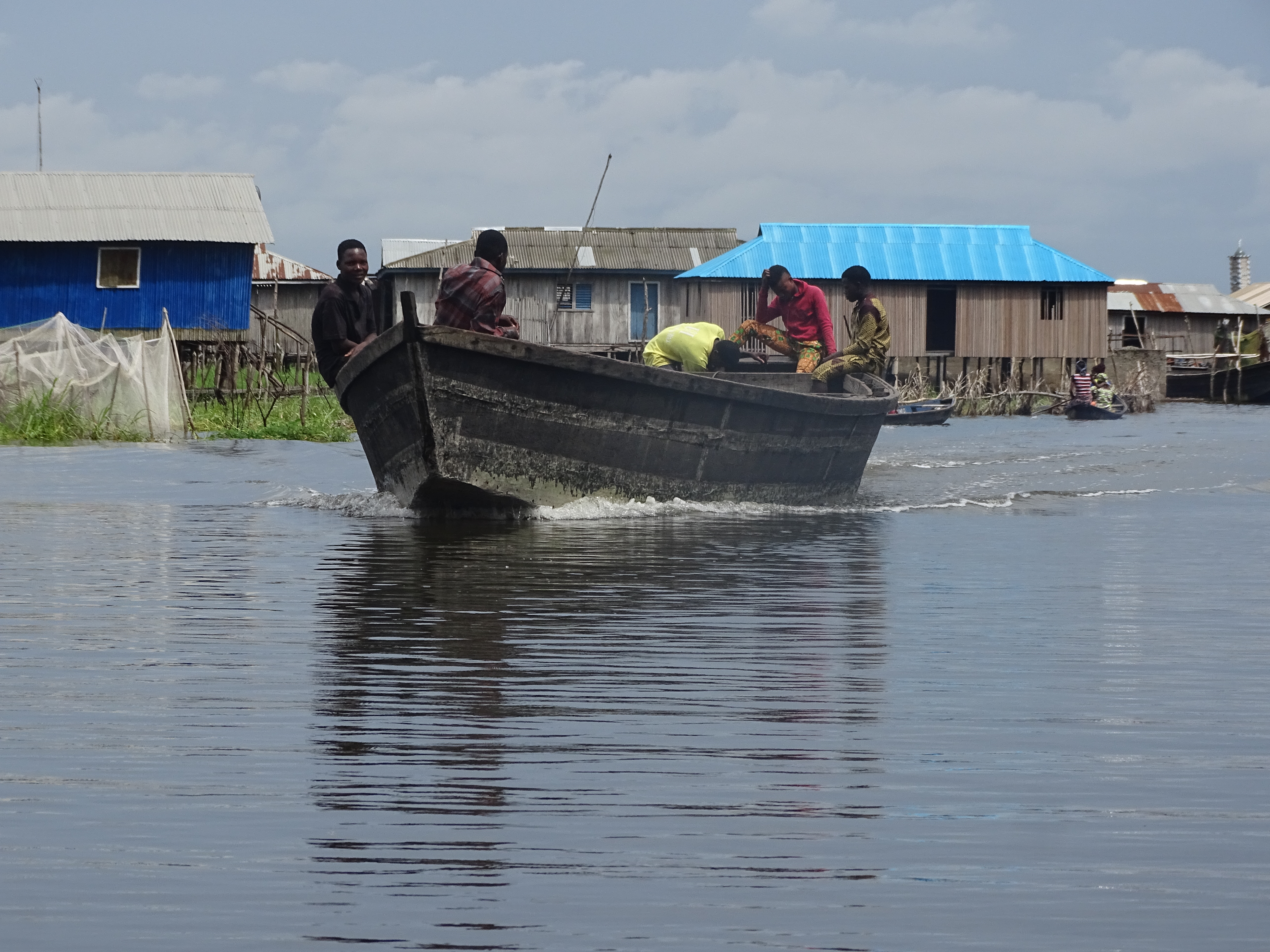
Français : « Rivières cristallines, lac posé tel un joyau sur des berges d’un vert presque phosphorescent, on n’entendait que des exclamations. Quelqu’un a écrit que le paysage, c’est le visage d’un pays. Ce visage-ci produisit aux voyageurs un effet inoubliable. » dit Sarah Dars dans son ouvrage Des myrtilles dans la yourte (2009). C\’est sur cette citation que nous vous invitons à découvrir la cité lacustre Ganvié, petite Venise d\’Afrique!
Le village lacustre Ganvié s’offre à vous. Première et plus importante cité lacustre d’Afrique de l’Ouest, Ganvié est une merveille qui recèle encore bien de beautés à vous offrir. En langue fon le nom Ganvié vient de « Gan » qui désigne « sauvé » et de « vié » qui désigne « collectivité ». Située sur le lac Nokoué, lequel s’étend jusqu’à Porto Novo, la capitale du Bénin, la cité lacustre Ganvié est constituée de quelques milliers de cases en bois construites sur des pilotis. Pour 277 km2, elle compte environ 30 000 habitants qui vivent essentiellement de la pêche. La visite à Ganvié se limite très souvent au village sur pilotis et attraits touristiques de la Cité. Or la cité de Ganvié mène vers une autre cité semi-lacustre, celle de Sô-Ava, et à la capitale du Bénin, Porto-Novo. Je trouve dommage que cet itinéraire soit rarement emprunté pourtant les paysages sont géniaux. Visiter Ganvié vous fera découvrir la présence chaleureuse et attentive de ses habitants prêts à vous faire découvrir leur univers et mode de vie. Vous y découvrirez les nénuphars sur les lagunes qui longent les traversées vers Porto-Novo et Avlékété (si vous en prenez la route), les pêcheurs dans leurs pirogues jetant sur l’eau les filets, vous y découvrirez également les méthodes artisanales de pêche au Bénin.English: "Crystalline rivers, lake set like a jewel on banks of an almost phosphorescent green, one heard only exclamations. Someone wrote that landscape is the face of a country. This face gave travelers an unforgettable effect. Says Sarah Dars in her book Blueberries in the Yurt (2009). It is on this quote that we invite you to discover the lake city Ganvié, little Venice of Africa!
The lakeside village Ganvié is open to you. First and most important lake city of West Africa, Ganvié is a marvel that still has many beauties to offer you. In language, the name Ganvié comes from "Gan" which means "saved" and "vied" which means "collectivity". Located on Lake Nokoué, which extends to Porto Novo, the capital of Benin, the lake city Ganvié is made up of a few thousand wooden boxes built on piles. For 277 km2, it has about 30,000 inhabitants who live mainly from fishing. The visit to Ganvié is very often limited to the village on stilts and tourist attractions of the city. But the city of Ganvie leads to another semi-lacustrine city, that of Sô-Ava, and the capital of Benin, Porto-Novo. I find it unfortunate that this route is rarely used but the landscapes are great. To visit Ganvié will make you discover the warm and attentive presence of its inhabitants ready to make you discover their universe and way of life. You will discover water lilies on the lagoons along the crossings to Porto-Novo and Avlékété (if you take the road), the fishermen in their canoes throwing on the water nets, you will also discover the artisanal methods of fishing at sea. Benin. |
| Date | Taken on 9 May 2019, 14:36:26 |
| Source | Own work |
| Author | AMADOU BAHLEMAN FARID |
| Camera location | | View this and other nearby images on: OpenStreetMap |
|---|
Licensing
[edit]
- You are free:
- to share – to copy, distribute and transmit the work
- to remix – to adapt the work
- Under the following conditions:
- attribution – You must give appropriate credit, provide a link to the license, and indicate if changes were made. You may do so in any reasonable manner, but not in any way that suggests the licensor endorses you or your use.
- share alike – If you remix, transform, or build upon the material, you must distribute your contributions under the same or compatible license as the original.
This image was uploaded as part of Wiki Loves Earth 2019.
|
 |
File history
Click on a date/time to view the file as it appeared at that time.
| Date/Time | Thumbnail | Dimensions | User | Comment | |
|---|---|---|---|---|---|
| current | 16:38, 26 June 2019 | | 5,184 × 3,888 (6.45 MB) | AMADOU BAHLEMAN FARID (talk | contribs) | User created page with UploadWizard |
You cannot overwrite this file.
File usage on Commons
There are no pages that use this file.
File usage on other wikis
The following other wikis use this file: