File:La Vérendrye Map.jpg

Original file (1,024 × 364 pixels, file size: 70 KB, MIME type: image/jpeg)
Captions
Captions
Summary
[edit]
| Description |
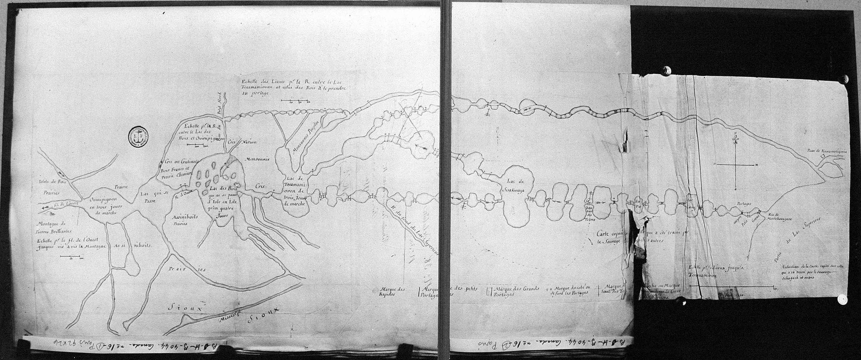
English: Map of Boundary Waters region, including Lake Superior, Kaministiquia River, Rainy Lake, Lake of the Woods, and Lake Winnipeg, drawn by Native guide Auchagah for La Vérendrye sometime around 1730. |
| Date | circa 1730 |
| Source |
France National Archives http://epe.lac-bac.gc.ca/100/206/301/lac-bac/explorers/data2.collectionscanada.gc.ca/ap/c/c016133.jpg |
| Author | Auchagah |
| Permission (Reusing this file) |
© Public Domain Credit: National Archives of Canada/C-016133 |
Licensing
[edit]
|
This work is in the public domain in its country of origin and other countries and areas where the copyright term is the author's life plus 70 years or fewer.
| |
| This file has been identified as being free of known restrictions under copyright law, including all related and neighboring rights. | |
Original upload log
[edit]
- 2007-03-23 19:02 BlueCanoe 1024×364× (71327 bytes) Map of [[Boundary Waters]] region, including [[Lake Superior]], [[Rainy Lake]], and [[Lake of the Woods]], drawn by Native guide Auchagah for [[Pierre Gaultier de Varennes, sieur de La Vérendrye|La Vérendrye]] © Public Domain Credit: National Archives
External links
[edit]
- Research Laboratories of Archaeology at University of North Carolina: Ochagach (Cree Indian); La Vérendrye, Pierre Gaultier de Varennes, sieur de (1685-1749) [ca. 1728]: [Carte copiée sur celle qui a été tracée par le sauvage Ochagach et autres, comprenant la région des Grands Lacs, depuis la "montagne de Pierres brilliantes" jusqu'au "Poste de Kamanestigovia", près du lac Supérieur, vers 1750.]
File history
Click on a date/time to view the file as it appeared at that time.
| Date/Time | Thumbnail | Dimensions | User | Comment | |
|---|---|---|---|---|---|
| current | 06:27, 22 June 2010 | 1,024 × 364 (70 KB) | Urdangaray (talk | contribs) | {{Information |Description={{en|Map of en:Boundary Waters region, including en:Lake Superior, en:Kaministiquia River, en:Rainy Lake, en:Lake of the Woods, and en:Lake Winnipeg, drawn by Native guide Auchagah for [[:en:P |
You cannot overwrite this file.
File usage on Commons
There are no pages that use this file.
File usage on other wikis
The following other wikis use this file:
- Usage on de.wikipedia.org
- Usage on en.wikipedia.org
- Usage on es.wikipedia.org
- Usage on fr.wikipedia.org
- Usage on it.wikipedia.org
- Usage on no.wikipedia.org