File:La Réole - rue Jacques Terrible, chemin Royal - circuit, boucle.jpg
Jump to navigation
Jump to search

Size of this preview: 800 × 450 pixels. Other resolutions: 320 × 180 pixels | 640 × 360 pixels | 1,024 × 576 pixels | 1,280 × 720 pixels | 2,048 × 1,152 pixels.
Original file (2,048 × 1,152 pixels, file size: 1.05 MB, MIME type: image/jpeg)
Captions
Captions
Add a one-line explanation of what this file represents
Summary
[edit]
| Description |
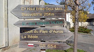
English: Circuit Haut Entre-Deux-Mers, Sauveterre 25 Km;
BL des Tuileries 14.7 Km; Circuit du Pays d'Auros (sic.), La Réole; Circuit du Pays d'Auros is an error. It should also be Circuit Haut Entre-Deux-Mers.Français : Circuit Haut Entre-Deux-Mers, Sauveterre 25 Km;
BL des Tuileries 14,7 Km; Circuit du Pays d'Auros (sic.), La Réole; Circuit du Pays d'Auros est une erreur. Ça devrait aussi être Circuit Haut Entre-Deux-Mers. |
| Date | |
| Source | Own work |
| Author | Philh-591 |
| Openstreetmap entry | Link to Openstreetmap |
| Object location | | View this and other nearby images on: OpenStreetMap |
|---|
| Camera location | | View this and other nearby images on: OpenStreetMap |
|---|
Licensing
[edit]
I, the copyright holder of this work, hereby publish it under the following license:
This file is licensed under the Creative Commons Attribution-Share Alike 4.0 International license.
- You are free:
- to share – to copy, distribute and transmit the work
- to remix – to adapt the work
- Under the following conditions:
- attribution – You must give appropriate credit, provide a link to the license, and indicate if changes were made. You may do so in any reasonable manner, but not in any way that suggests the licensor endorses you or your use.
- share alike – If you remix, transform, or build upon the material, you must distribute your contributions under the same or compatible license as the original.
File history
Click on a date/time to view the file as it appeared at that time.
| Date/Time | Thumbnail | Dimensions | User | Comment | |
|---|---|---|---|---|---|
| current | 21:42, 11 October 2021 | | 2,048 × 1,152 (1.05 MB) | Philh-591 (talk | contribs) | Uploaded own work with UploadWizard |
You cannot overwrite this file.
File usage on Commons
The following 2 pages use this file:
File usage on other wikis
The following other wikis use this file:
- Usage on fr.wikipedia.org