File:La2-demis-ladogaRu.png
Jump to navigation
Jump to search
Size of this preview: 488 × 600 pixels. Other resolutions: 195 × 240 pixels | 638 × 784 pixels.
Original file (638 × 784 pixels, file size: 75 KB, MIME type: image/png)
Captions
Captions
Add a one-line explanation of what this file represents
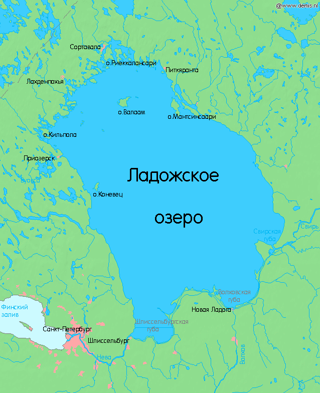
| Description | Ладожское озеро. Lake Ladoga in Russia. |
| Date | |
| Source | Own work |
| Author | Peterburg23 |
| Other versions | Magyar svg |
Bounding box West 29.4°, South 59.6°, East 33.4°, North 62.0°.
Center at 60°48′00″N 31°24′00″E / 60.80000°N 31.40000°E.
I, the copyright holder of this work, hereby publish it under the following licenses:

|
Permission is granted to copy, distribute and/or modify this document under the terms of the GNU Free Documentation License, Version 1.2 or any later version published by the Free Software Foundation; with no Invariant Sections, no Front-Cover Texts, and no Back-Cover Texts. A copy of the license is included in the section entitled GNU Free Documentation License. |
This file is licensed under the Creative Commons Attribution 3.0 Unported license.
- You are free:
- to share – to copy, distribute and transmit the work
- to remix – to adapt the work
- Under the following conditions:
- attribution – You must give appropriate credit, provide a link to the license, and indicate if changes were made. You may do so in any reasonable manner, but not in any way that suggests the licensor endorses you or your use.
You may select the license of your choice.
This image is in the public domain because it came from the site https://www.demis.nl/products/web-map-server/examples/ and was released by the copyright holder. Permission is granted to copy, distribute and/or modify this map since it is based on free of copyright images from: www.demis.nl. See also approval email on de.wp and its clarification.
|
| This work has been released into the public domain by its copyright holder, www.demis.nl. This applies worldwide. In some countries this may not be legally possible; if so: www.demis.nl grants anyone the right to use this work for any purpose, without any conditions, unless such conditions are required by law.
|
File history
Click on a date/time to view the file as it appeared at that time.
| Date/Time | Thumbnail | Dimensions | User | Comment | |
|---|---|---|---|---|---|
| current | 22:52, 16 January 2010 | | 638 × 784 (75 KB) | Peterburg23 (talk | contribs) | Lake Ladoga in Russia. Bounding box West 29.4°, South 59.6°, East 33.4°, North 62.0°. Center at {{coor d|60.80000|N|31.40000|E|scale:1439999}}. {{demis-pd}} Category:Maps of lakes Category:Maps of Russia Category:Lake Ladoga |
You cannot overwrite this file.
File usage on Commons
There are no pages that use this file.
File usage on other wikis
The following other wikis use this file:
- Usage on ru.wikipedia.org