File:LIRR 1891 Union Course station.jpg
Jump to navigation
Jump to search
No higher resolution available.
LIRR_1891_Union_Course_station.jpg (523 × 435 pixels, file size: 80 KB, MIME type: image/jpeg)
Captions
Captions
Add a one-line explanation of what this file represents
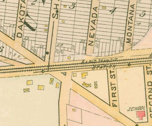
This is a portion of an 1891 map of Queens, New York, United States, showing Union Course station. Nevada and Montana Avenues are now 81st and 82nd Streets. The map, Wolverton Plate 17, was scanned by the New York Public Library with Digital Image ID 1523087.
| Object location | | View this and other nearby images on: OpenStreetMap |
|---|
|
This is a faithful photographic reproduction of a two-dimensional, public domain work of art. The work of art itself is in the public domain for the following reason:
The official position taken by the Wikimedia Foundation is that "faithful reproductions of two-dimensional public domain works of art are public domain". This photographic reproduction is therefore also considered to be in the public domain in the United States. In other jurisdictions, re-use of this content may be restricted; see Reuse of PD-Art photographs for details. {{PD-Art}} template without license parameter: please specify why the underlying work is public domain in both the source country and the United States
(Usage: {{PD-Art|1=|deathyear=''year of author's death''|country=''source country''}}, where parameter 1= can be PD-old-auto, PD-old-auto-expired, PD-old-auto-1996, PD-old-100 or similar. See Commons:Multi-license copyright tags for more information.) | ||||
File history
Click on a date/time to view the file as it appeared at that time.
| Date/Time | Thumbnail | Dimensions | User | Comment | |
|---|---|---|---|---|---|
| current | 21:44, 13 February 2007 | | 523 × 435 (80 KB) | NE2 (talk | contribs) | This is a portion of an 1891 map of Queens, New York, United States, showing Union Course station. The map was scanned by the New York Public Library with Digital Image ID 1523087. {{PD-art}} Category:Long Island Rail Road Category:Maps |
You cannot overwrite this file.
File usage on Commons
There are no pages that use this file.