File:LGB airport map.PNG
Jump to navigation
Jump to search

Size of this preview: 417 × 599 pixels. Other resolutions: 167 × 240 pixels | 334 × 480 pixels | 791 × 1,136 pixels.
Original file (791 × 1,136 pixels, file size: 118 KB, MIME type: image/png)
Captions
Captions
Add a one-line explanation of what this file represents
Summary
[edit]
| Description |
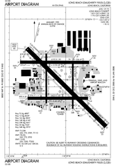
English: FAA diagram for Long Beach Airport (IATA: LGB, ICAO: KLGB) in Long Beach, California, United States. |
| Date | |
| Source | http://naco.faa.gov/d-tpp/0512/00236AD.PDF (effective 22 DEC 2005 to 19 JAN 2006). Note: this URL changes monthly, see airport article's external links for a link to the current FAA diagram. |
| Author | National Aeronautical Charting Office (NACO), a department of the Federal Aviation Administration (FAA). |
| Permission (Reusing this file) |
Public Domain |
Licensing
[edit]
This image or file is a work of a Federal Aviation Administration employee, taken or made as part of that person's official duties. As a work of the U.S. federal government, the image is in the public domain in the United States.
|
 |
File history
Click on a date/time to view the file as it appeared at that time.
| Date/Time | Thumbnail | Dimensions | User | Comment | |
|---|---|---|---|---|---|
| current | 22:45, 6 January 2006 | | 791 × 1,136 (118 KB) | Cmprince (talk | contribs) | Aiport diagram for Long Beach Airport {{PD-USGov-FAA}} |
You cannot overwrite this file.
File usage on Commons
The following page uses this file:
File usage on other wikis
The following other wikis use this file:
- Usage on pl.wikipedia.org
- Usage on www.wikidata.org