File:LGA airport map.gif
Jump to navigation
Jump to search
Size of this preview: 397 × 599 pixels. Other resolutions: 159 × 240 pixels | 500 × 755 pixels.
Original file (500 × 755 pixels, file size: 136 KB, MIME type: image/gif)
Captions
Captions
Add a one-line explanation of what this file represents

|
File:LGA Airport Diagram.svg is a vector version of this file. It should be used in place of this GIF file when not inferior.
File:LGA airport map.gif → File:LGA Airport Diagram.svg
For more information, see Help:SVG. |
 |

|
This file has been superseded by LGA Airport Diagram.svg. It is recommended to use the other file. Please note that deleting superseded images requires consent.
|

|
Transwiki approved by: w:en:User:Dmcdevit
This image was copied from wikipedia:en. The original description was:
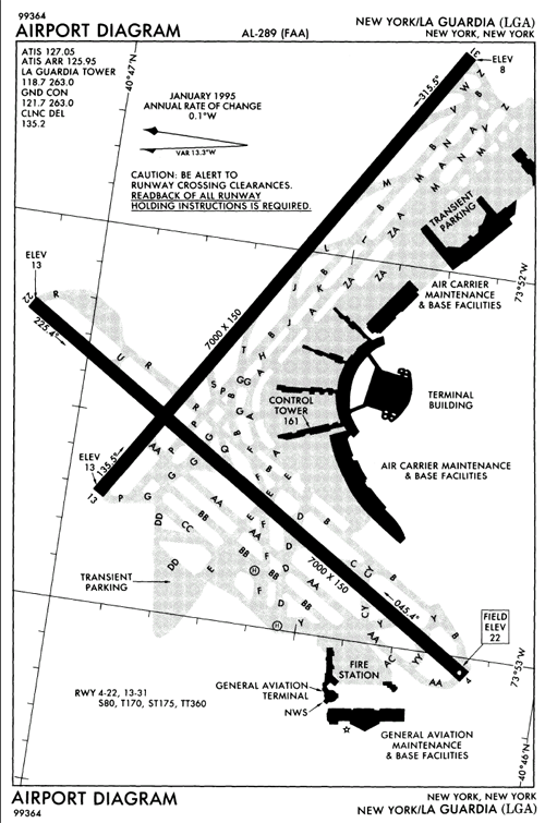
FAA diagram of LaGuardia Airport.
Source: http://naco.faa.gov/d-tpp/0702/00289AD.PDF
This image or file is a work of a Federal Aviation Administration employee, taken or made as part of that person's official duties. As a work of the U.S. federal government, the image is in the public domain in the United States.
|
 |
Original upload log
[edit]
| date/time | username | resolution | size | edit summary |
|---|---|---|---|---|
| 22:12, 3 September 2004 | w:en:User:Sekicho | 500×755 | 136 KB | FAA diagram of LaGuardia Airport. |
Image description page history
[edit]
| link | date/time | username | edit summary |
|---|---|---|---|
| http://en.wikipedia.org/w/index.php?title=Image:LGA_airport_map.gif&redirect=no&oldid=16743878 | 05:59, 16 September 2007 | w:en:User:Dmcdevit | |
| http://en.wikipedia.org/w/index.php?title=Image:LGA_airport_map.gif&redirect=no&oldid=16743878 | 02:06, 19 June 2005 | w:en:User:Daniel Case | |
| http://en.wikipedia.org/w/index.php?title=Image:LGA_airport_map.gif&redirect=no&oldid=15421789 | 23:20, 21 May 2005 | w:en:User:RedWolf | |
| http://en.wikipedia.org/w/index.php?title=Image:LGA_airport_map.gif&redirect=no&oldid=14040523 | 22:12, 3 September 2004 | w:en:User:Sekicho | (FAA diagram of LaGuardia Airport.) |
File history
Click on a date/time to view the file as it appeared at that time.
| Date/Time | Thumbnail | Dimensions | User | Comment | |
|---|---|---|---|---|---|
| current | 11:57, 16 September 2007 | | 500 × 755 (136 KB) | BetacommandBot (talk | contribs) | Transwiki approved by: w:en:User:Dmcdevit This image was copied from wikipedia:en. The original description was: FAA diagram of LaGuardia Airport. {{PD-USGov-FAA}} === File history === {| class=wikitable ! date/time || username || resolution || siz |
You cannot overwrite this file.
File usage on Commons
The following page uses this file:
File usage on other wikis
The following other wikis use this file:
- Usage on da.wikipedia.org
- Usage on sq.wikipedia.org