File:Líbano.jpg
Jump to navigation
Jump to search
Size of this preview: 800 × 450 pixels. Other resolutions: 320 × 180 pixels | 640 × 360 pixels | 1,024 × 576 pixels | 1,280 × 720 pixels | 2,560 × 1,440 pixels | 5,452 × 3,067 pixels.
Original file (5,452 × 3,067 pixels, file size: 4.75 MB, MIME type: image/jpeg)
Captions
Captions
Add a one-line explanation of what this file represents
Summary
[edit]
| Description |
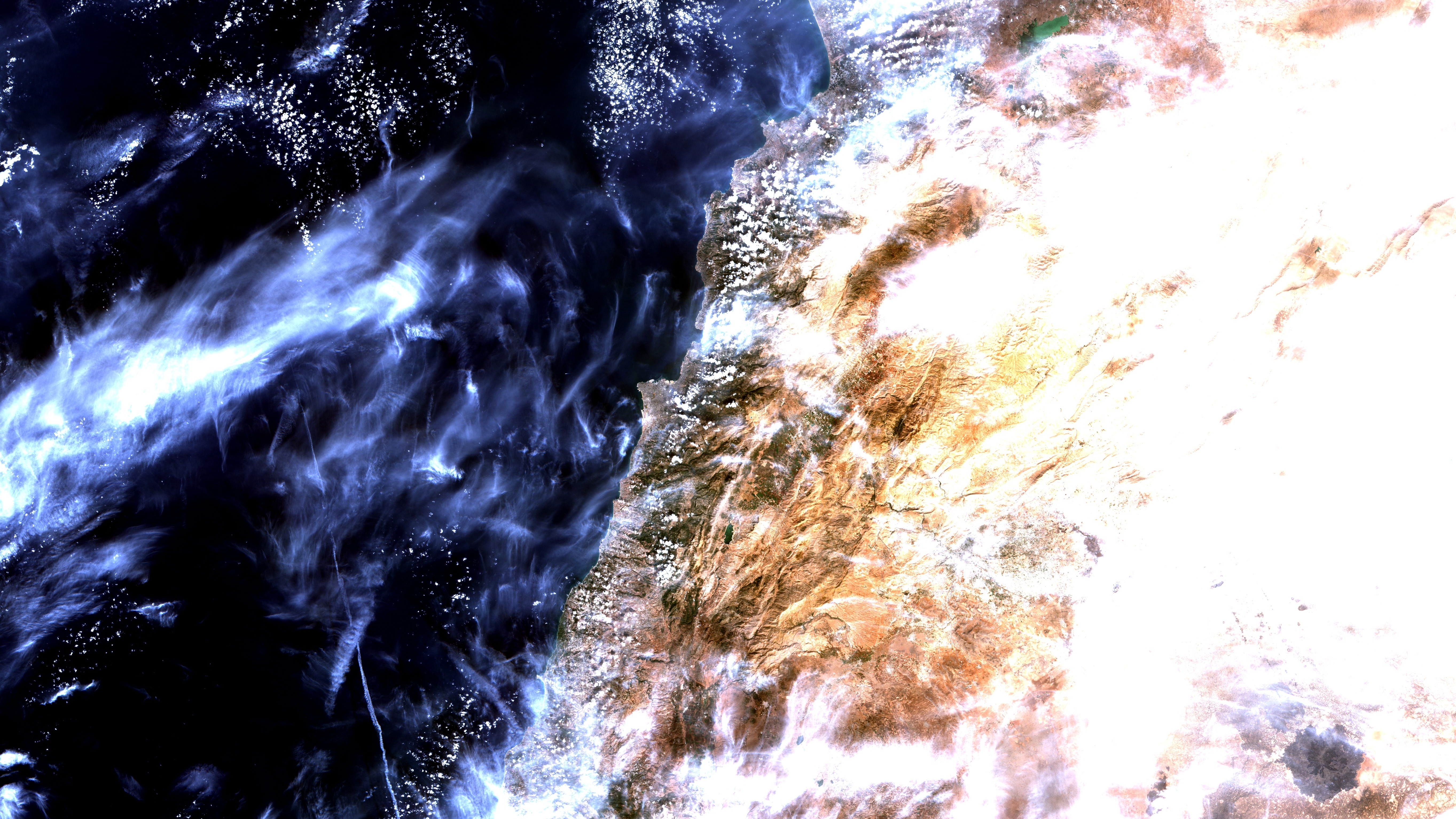
Português: Beirute, Líbano, em imagem CBERS4 AWFI. Para escala, essa imagem no instagram tem 69 x 69 km. Linhas brancas que se cruzam no centro da imagem, são as pistas do seu aeroporto. Áreas urbanas em salpicado. Foi gravada à bordo para atender acionamento do Disasters Charter devido aos piores incêndios florestais em décadas; daí a imagem estar coberta por plumas de fumaça em branco azulado ( +info no link abaixo). Em verde escuro floresta, em marrom gramineas, arbustos e solo nú. A grossa linha amarela, à dir. embaixo da imagem, são rochas expostas no Monte Líbano. A O do Monte está o Vale do Beca, com agricultura em verde claro; onde em verde esmeralda escuro, se destaca o reservatório de Qaraoun. Nuvens em branco e suas sombras em preto / Beirute, Lebanon, at a CBERS4 AWFI image. For scale instagram image has 69 x 69 km. Crossed whitelines at image center are its airport landing strips. Urban areas appear in saltpepper. Image was recorded on board to attend a Disasters Charter activation due to the worst wildfires in decades; that´s why it´s covered by smoke plumes, in blueish white ( +info at link below). Forest in green, and in brown, grass, bushes and barren ground. Thick yellow line, at image right bottom, is Mount Lebanon. To its W is Beqaa Valley, with agriculture in light green; there also sits Qaraon reservoir, in dark emerald green. Clouds in white and its shadows in black.
Imagem / Image CBERS4 AWFI Líbano Coordenadas do centro da imagem / Image center: 33°49'30.4"N 35°29'26.4"E Data / Date: 18-10-2019 / 2019-10-18 RGB151413 (cor verdadeira / true color) Cena / Scene: 086 / 063 Autor / Author: Oton Barros (DSR/OBT/INPE) Imagem em HD / HD imagem Visite-nos em www.dsr.inpe.br |
| Date | |
| Source | https://www.flickr.com/photos/153282474@N02/48943636086/ |
| Author | Coordenação-Geral de Observação da Terra/INPE |
Licensing
[edit]
This file is licensed under the Creative Commons Attribution-Share Alike 2.0 Generic license.
- You are free:
- to share – to copy, distribute and transmit the work
- to remix – to adapt the work
- Under the following conditions:
- attribution – You must give appropriate credit, provide a link to the license, and indicate if changes were made. You may do so in any reasonable manner, but not in any way that suggests the licensor endorses you or your use.
- share alike – If you remix, transform, or build upon the material, you must distribute your contributions under the same or compatible license as the original.
| This image was originally posted to Flickr by Coordenação-Geral de Observação da Terra/INPE at https://flickr.com/photos/153282474@N02/48943636086. It was reviewed on 9 April 2020 by FlickreviewR 2 and was confirmed to be licensed under the terms of the cc-by-sa-2.0. |
File history
Click on a date/time to view the file as it appeared at that time.
| Date/Time | Thumbnail | Dimensions | User | Comment | |
|---|---|---|---|---|---|
| current | 10:12, 9 April 2020 | | 5,452 × 3,067 (4.75 MB) | Jo-Jo Eumerus (talk | contribs) | Uploaded a work by Coordenação-Geral de Observação da Terra/INPE from https://www.flickr.com/photos/153282474@N02/48943636086/ with UploadWizard |
You cannot overwrite this file.
File usage on Commons
The following 2 pages use this file:
- لبنان / Liban
- File:Líbano (48943636086).jpg (file redirect)
.jpg&redirect=no)