File:Kwilu River entering Kwango River NASA.jpg
Jump to navigation
Jump to search
No higher resolution available.
Kwilu_River_entering_Kwango_River_NASA.jpg (450 × 225 pixels, file size: 62 KB, MIME type: image/jpeg)
Captions
Captions
Add a one-line explanation of what this file represents
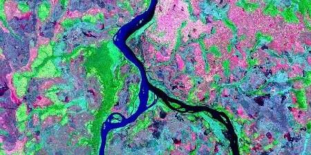
Kwango River entering Kasai River in the Democratic Republic of the Congo

| This image is in the public domain because it is a screenshot from NASA’s globe software World Wind using a public domain layer, such as Blue Marble, MODIS, Landsat, SRTM, USGS or GLOBE.
|
 |
File history
Click on a date/time to view the file as it appeared at that time.
| Date/Time | Thumbnail | Dimensions | User | Comment | |
|---|---|---|---|---|---|
| current | 18:07, 25 August 2023 | | 450 × 225 (62 KB) | Motivum (talk | contribs) | File:Kwango River entering Kasai River NASA.jpg cropped 56 % horizontally, 68 % vertically using CropTool with lossless mode. |
You cannot overwrite this file.
File usage on Commons
The following page uses this file:
File usage on other wikis
The following other wikis use this file:
- Usage on ru.wikipedia.org