File:Kurdish population by region (KONDA 2010).svg
Jump to navigation
Jump to search

Size of this PNG preview of this SVG file: 800 × 343 pixels. Other resolutions: 320 × 137 pixels | 640 × 274 pixels | 1,024 × 439 pixels | 1,280 × 549 pixels | 2,560 × 1,098 pixels | 1,579 × 677 pixels.
Original file (SVG file, nominally 1,579 × 677 pixels, file size: 1.67 MB)
Captions
Captions
Add a one-line explanation of what this file represents

|
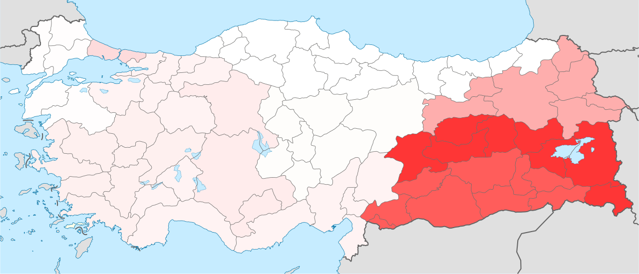
A raster version of this image is available. It should be used in place of this vector image when superior. Referenced source does not have data for provinces, but for regions.
File:Kurdish population by region (KONDA 2010).svg → File:Kurdish population by region (KONDA 2010).png
In general, it is better to use a good SVG version. |
.png)
Summary
[edit].svg&action=edit§ion=1)
| Description |
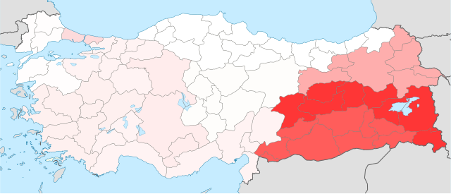
English: Map showing the percentage of Kurdish population in each of the statistical regions of Turkey. Source: Kürt Meselesi̇ni̇ Yeni̇den Düşünmek (July 2010), pp. 19-20. |
| Date | (UTC) |
| Source |
This file was derived from: Nevşehir in Turkey.svg: |
| Author |
|
| Region | Region (Turkish name) | % Kurdish |
|---|---|---|
| Central Eastern Anatolia | Ortadoğu Anadolu | 79.1% |
| Southeastern Anatolia | Güneydoğu Anadolu | 64.1% |
| Northeast Anatolia | Kuzeydoğu Anadolu | 32.0% |
| Istanbul | Istanbul | 14.8% |
| Western Anatolia | Bati Anadolu | 7.7% |
| Aegean | Ege | 6.1% |
| Mediterranean | Akdeniz | 4.9% |
| East Marmara | Doğu Marmara | 4.9% |
| Central Anatolia | Orta Anadolu | 1.3% |
| West Marmara | Bati Marmara | 0.9% |
| Western Black Sea | Bati Karadeniz | 0.3% |
| Eastern Black Sea | Doğu Karadeniz | 0.1% |
Licensing
[edit].svg&action=edit§ion=2)
I, the copyright holder of this work, hereby publish it under the following licenses:

|
Permission is granted to copy, distribute and/or modify this document under the terms of the GNU Free Documentation License, Version 1.2 or any later version published by the Free Software Foundation; with no Invariant Sections, no Front-Cover Texts, and no Back-Cover Texts. A copy of the license is included in the section entitled GNU Free Documentation License. |
This file is licensed under the Creative Commons Attribution-Share Alike Attribution-Share Alike 4.0 International, 3.0 Unported, 2.5 Generic, 2.0 Generic and 1.0 Generic license.
- You are free:
- to share – to copy, distribute and transmit the work
- to remix – to adapt the work
- Under the following conditions:
- attribution – You must give appropriate credit, provide a link to the license, and indicate if changes were made. You may do so in any reasonable manner, but not in any way that suggests the licensor endorses you or your use.
- share alike – If you remix, transform, or build upon the material, you must distribute your contributions under the same or compatible license as the original.
You may select the license of your choice.
File history
Click on a date/time to view the file as it appeared at that time.
| Date/Time | Thumbnail | Dimensions | User | Comment | |
|---|---|---|---|---|---|
| current | 08:20, 11 June 2013 | | 1,579 × 677 (1.67 MB) | Underlying lk (talk | contribs) | {{Information |Description={{en|1=Map showing the percentage of Kurdish population in each of the statistical regions of Turkey. Source: [http://www.konda.com.tr/tr/raporlar/2010_12_KONDA_Kurt_Meselesini_Yeniden_Dusunmek.pdf Kürt Meselesi̇ni̇ Yeni̇... |
You cannot overwrite this file.
File usage on Commons
There are no pages that use this file.
File usage on other wikis
The following other wikis use this file:
- Usage on fa.wikipedia.org
- Usage on zh.wikipedia.org
.svg&oldid=497654121)