File:Kuczbork-Osada (gmina) location map.png
Jump to navigation
Jump to search

Size of this preview: 582 × 599 pixels. Other resolutions: 233 × 240 pixels | 466 × 480 pixels | 817 × 841 pixels.
Original file (817 × 841 pixels, file size: 63 KB, MIME type: image/png)
Captions
Captions
Add a one-line explanation of what this file represents
| Description |
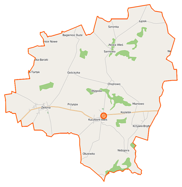
Polski: Mapa gminy Kuczbork-Osada, Polska
English: Map of Gmina Kuczbork-Osada, Poland |
|||||||||
| Date | ||||||||||
| Source | You may find a page on the OpenStreetMap wiki page for Kuczbork-Osada (gmina) | |||||||||
| Creator |
OpenStreetMap contributors OpenStreetMap contributors |
|||||||||
| Permission (Reusing this file) |
OpenStreetMap data is available under the Open Database License (details). Map tiles are licensed under the Creative Commons Attribution-ShareAlike 2.0 license (CC-BY-SA 2.0).
This file is licensed under the Creative Commons Attribution-Share Alike 2.0 Generic license.
|
|||||||||
| Geotemporal data | ||||||||||
| Bounding box |
|
|||||||||
| Georeferencing | If inappropriate please set warp_status = skip to hide. | |||||||||
File history
Click on a date/time to view the file as it appeared at that time.
| Date/Time | Thumbnail | Dimensions | User | Comment | |
|---|---|---|---|---|---|
| current | 11:34, 18 October 2014 | | 817 × 841 (63 KB) | VanWiel (talk | contribs) | {{OpenStreetMap | name = Kuczbork-Osada (gmina) | location = Kuczbork-Osada (gmina) | description = {{pl|Mapa gminy Kuczbork-Osada, Polska}} {{en|Map of Gmina Kuczbork-Osada, Poland}} | top = 53.1713 | left... |
You cannot overwrite this file.
File usage on Commons
There are no pages that use this file.
File usage on other wikis
The following other wikis use this file:
- Usage on fr.wikipedia.org
- Usage on pl.wikipedia.org
- Kuczbork-Osada (gmina)
- Bagienice Duże
- Bagienice Nowe
- Chodubka
- Gościszka
- Krzywki-Bratki
- Kuczbork-Osada
- Kuczbork-Wieś
- Kozielsk (Polska)
- Nidzgora
- Olszewko (województwo mazowieckie)
- Szronka
- Bagienice Małe (województwo mazowieckie)
- Łążek (województwo mazowieckie)
- Osowa (województwo mazowieckie)
- Sarnowo (województwo mazowieckie)
- Chojnowo (powiat żuromiński)
- Mianowo (powiat żuromiński)
- Zielona (powiat żuromiński)
- Nowa Wieś (gmina Kuczbork-Osada)
- Niedziałki (województwo mazowieckie)
- Przyspa
- Wygoda (powiat żuromiński)
- Parafia św. Bartłomieja Apostoła w Kuczborku
- Cmentarz żydowski w Kuczborku-Osadzie
- Gościszka-Baraki
- Niedziałki-Nowopole
- Sadykierz (powiat żuromiński)
- Kościół św. Bartłomieja w Kuczborku-Osadzie
- Moduł:Mapa/dane/Kuczbork-Osada (gmina)
- Parafia św. Józefa w Sarnowie
- Parafia św. Marcina w Zielonej
- Usage on pl.wikibooks.org
_location_map.png&oldid=519972833)