File:Kuala Lumpur locator map.svg
Jump to navigation
Jump to search

Size of this PNG preview of this SVG file: 428 × 599 pixels. Other resolutions: 171 × 240 pixels | 343 × 480 pixels | 548 × 768 pixels | 731 × 1,024 pixels | 1,463 × 2,048 pixels | 500 × 700 pixels.
Original file (SVG file, nominally 500 × 700 pixels, file size: 306 KB)
Captions
Captions
Add a one-line explanation of what this file represents
Summary
[edit]
| Description |
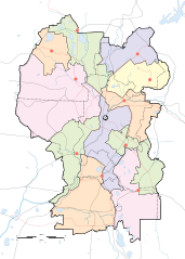
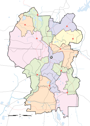
English: Map of w:Kuala Lumpur divided according to constituencies with highways (black) and major roads (red). City centre is marked by a Star Button and constituency towns marked by Red Buttons. Mukims (communes) are marked with dotted lines. |
||
| Date | |||
| Source |
Own work by uploader for w:Wikipedia:WikiProject Malaysia/Cartography New boundaries were from SPR Malaysia and Tindak Malaysia (2018) |
||
| Author |
|
||
| Other versions | File:Kuala Lumpur subdistrict locator map.svg |
Licensing
[edit]
I, the copyright holder of this work, hereby publish it under the following license:
This file is licensed under the Creative Commons Attribution-Share Alike 4.0 International license.
- You are free:
- to share – to copy, distribute and transmit the work
- to remix – to adapt the work
- Under the following conditions:
- attribution – You must give appropriate credit, provide a link to the license, and indicate if changes were made. You may do so in any reasonable manner, but not in any way that suggests the licensor endorses you or your use.
- share alike – If you remix, transform, or build upon the material, you must distribute your contributions under the same or compatible license as the original.
File history
Click on a date/time to view the file as it appeared at that time.
| Date/Time | Thumbnail | Dimensions | User | Comment | |
|---|---|---|---|---|---|
| current | 19:50, 29 April 2020 | | 500 × 700 (306 KB) | *angys* (talk | contribs) | add mukim boundaries |
| 19:18, 29 April 2020 |  | 500 × 700 (293 KB) | *angys* (talk | contribs) | Refined boundary, many thanks to Tindak Malaysia | |
| 18:00, 10 September 2018 |  | 500 × 700 (379 KB) | *angys* (talk | contribs) | new seat boundary from File:Selangor WPKL PRU14.svg | |
| 11:56, 22 June 2009 |  | 500 × 700 (307 KB) | Mdzafri (talk | contribs) | {{Information |Description={{en|1=Map of w:Kuala Lumpur divided according to constituencies with highways (black) and major roads (red). City centre is marked by a Star Button and constituency towns marked by Red Buttons.}} |Source=Own work by uploade |
You cannot overwrite this file.
File usage on Commons
The following page uses this file:
File usage on other wikis
The following other wikis use this file:
- Usage on ar.wikipedia.org
- Usage on bjn.wikipedia.org
- Usage on ceb.wikipedia.org
- Usage on en.wikipedia.org
- Bangsar
- Taman Tun Dr Ismail
- RMAF Kuala Lumpur Air Base
- Wangsa Maju
- Islamic Arts Museum Malaysia
- User:Mdzafri
- Module:Location map/data/Malaysia Kuala Lumpur/doc
- Abdul Rahman Auf Mosque
- Kuala Lumpur Hospital
- Wikipedia:Meetup/Kuala Lumpur
- The Boulevard Hotel Kuala Lumpur
- Module:Location map/data/Malaysia Kuala Lumpur
- Wikipedia:Graphics Lab/Map workshop/Archive/Jun 2018
- 2019 Malaysia M3 League
- 2020 Malaysia M3 League
- Wikipedia:Graphics Lab/Map workshop/Archive/Feb 2020
- Usage on fa.wikipedia.org
- Usage on fr.wikipedia.org
- Usage on he.wikipedia.org
- Usage on id.wikipedia.org
- Usage on jv.wikipedia.org
- Usage on kn.wikipedia.org
- Usage on ms.wikipedia.org
- Usage on mt.wikipedia.org
- Usage on pl.wikipedia.org
View more global usage of this file.