File:Krosno location map.png
Jump to navigation
Jump to search
Size of this preview: 606 × 599 pixels. Other resolutions: 243 × 240 pixels | 486 × 480 pixels | 783 × 774 pixels.
Original file (783 × 774 pixels, file size: 620 KB, MIME type: image/png)
Captions
Captions
Add a one-line explanation of what this file represents
| Description |
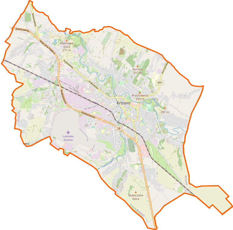
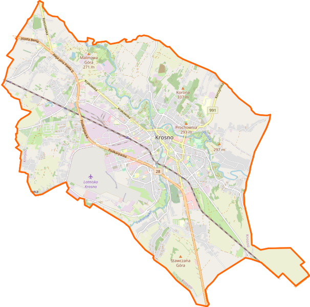
Location map of Krosno, Poland This map of Krosno was created from OpenStreetMap project data, collected by the community. This map may be incomplete, and may contain errors. Don't rely solely on it for navigation. |
|||||||||
| Date | ||||||||||
| Source | You may find a page on the OpenStreetMap wiki page for Krosno | |||||||||
| Creator |
OpenStreetMap contributors OpenStreetMap contributors |
|||||||||
| Permission (Reusing this file) |
OpenStreetMap data is available under the Open Database License (details). Map tiles are licensed under the Creative Commons Attribution-ShareAlike 2.0 license (CC-BY-SA 2.0).
This file is licensed under the Creative Commons Attribution-Share Alike 2.0 Generic license.
|
|||||||||
| Geotemporal data | ||||||||||
| Bounding box |
|
|||||||||
| Georeferencing | If inappropriate please set warp_status = skip to hide. | |||||||||
File history
Click on a date/time to view the file as it appeared at that time.
| Date/Time | Thumbnail | Dimensions | User | Comment | |
|---|---|---|---|---|---|
| current | 23:17, 2 February 2021 | | 783 × 774 (620 KB) | Szturnek (talk | contribs) | Kur, jednak automat dobrze mówił i po prostu nie zapisałem tej wersji przyciętej xD |
| 23:14, 2 February 2021 |  | 867 × 797 (687 KB) | Szturnek (talk | contribs) | Wersja z nieco obciętą pustą przestrzenią | |
| 23:13, 2 February 2021 |  | 517 × 586 (357 KB) | Szturnek (talk | contribs) | Chce wrzucić wersje z obciętym pustym miejscem, ale nie mogę, bo automau uznaje, że są identyczne, choć nie są | |
| 22:44, 2 February 2021 |  | 867 × 797 (687 KB) | Szturnek (talk | contribs) | Aktualizacja granic + wycięcie | |
| 14:47, 10 November 2013 |  | 517 × 586 (357 KB) | Powerek38 (talk | contribs) | VicuñaUploader 1.18 |
You cannot overwrite this file.
File usage on Commons
There are no pages that use this file.
File usage on other wikis
The following other wikis use this file:
- Usage on pl.wikipedia.org
- I Liceum Ogólnokształcące im. Mikołaja Kopernika w Krośnie
- Lotnisko Krosno
- Suchodół (Krosno)
- Turaszówka
- Krosno Polanka
- Krosno (stacja kolejowa)
- Białobrzegi (Krosno)
- Zawodzie (Krosno)
- Olszyny (struga)
- Krościenko Niżne
- Polanka (Krosno)
- Bitwa pod Krosnem
- Krosno Miasto
- Krosno Turaszówka
- Bazylika kolegiacka Świętej Trójcy w Krośnie
- Kościół i Klasztor oo. Franciszkanów w Krośnie
- Kościół św. Wojciecha w Krośnie
- Kościół i klasztor oo. kapucynów w Krośnie
- Kościół Najświętszej Maryi Panny Królowej Polski w Krośnie
- Cmentarz żydowski w Krośnie
- Krośnieńskie Huty Szkła „Krosno”
- Państwowa Akademia Nauk Stosowanych w Krośnie
- Parafia Trójcy Przenajświętszej w Krośnie
- Parafia Nawiedzenia Najświętszej Maryi Panny w Krośnie
- Parafia św. Wojciecha i Matki Bożej Częstochowskiej w Krośnie
- Parafia Miłosierdzia Bożego w Krośnie
- Parafia Najświętszej Maryi Panny Królowej Polski w Krośnie
- Parafia Najświętszego Serca Pana Jezusa w Krośnie
- Parafia Podwyższenia Krzyża Świętego w Krośnie
- Parafia Ducha Świętego w Krośnie
- Parafia św. Piotra Apostoła i św. Jana z Dukli w Krośnie
- Zbór Kościoła Adwentystów Dnia Siódmego w Krośnie
- Krośnieńska Biblioteka Publiczna
- Lotnisko Iwonicz
- Lądowisko Krosno-Szpital
- Muzeum Rzemiosła w Krośnie
- Pomnik Mikołaja Kopernika w Krośnie
- Moduł:Mapa/dane/Krosno
- Stary Cmentarz w Krośnie
- Ulica Podkarpacka w Krośnie
- Ulica Bieszczadzka w Krośnie
- Aleja Jana Pawła II w Krośnie
- Ulica Krakowska w Krośnie
- Cmentarz Komunalny w Krośnie
- Ulica Lwowska w Krośnie
- Wikipedysta:Grawiton/Ulica Niepodległości w Krośnie
- Pomnik Ignacego Łukasiewicza w Krośnie
- Pomnik Ofiar Katynia w Krośnie
- Wikipedysta:Grawiton/Kościół pw. św. Piotra Apostoła i św. Jana z Dukli w Krośnie
- Stadion MOSiR Krosno
View more global usage of this file.