File:Krosno Odrzańskie (gmina) location map.png

Original file (1,877 × 1,256 pixels, file size: 490 KB, MIME type: image/png)
Captions
Captions
Summary
[edit]_location_map.png&action=edit§ion=1)
| Description |
English: Location map |
| Date | |
| Source | Own work |
| Author | Smat |
| Description |
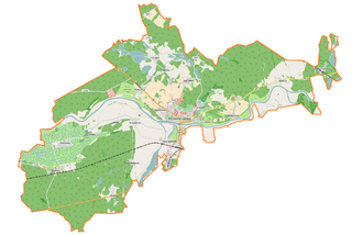
Polski: Mapa gminy Krosno Odrzańskie, Polska
English: Map of Krosno Odrzańskie (gmina), Poland |
|||||||||
| Date | ||||||||||
| Source | You may find a page on the OpenStreetMap wiki page for Krosno Odrzańskie (gmina) | |||||||||
| Creator |
OpenStreetMap contributors OpenStreetMap contributors |
|||||||||
| Permission (Reusing this file) |
OpenStreetMap data is available under the Open Database License (details). Map tiles are licensed under the Creative Commons Attribution-ShareAlike 2.0 license (CC-BY-SA 2.0).
This file is licensed under the Creative Commons Attribution-Share Alike 2.0 Generic license.
|
|||||||||
| Geotemporal data | ||||||||||
| Bounding box |
|
|||||||||
| Georeferencing | If inappropriate please set warp_status = skip to hide. | |||||||||
Licensing
[edit]_location_map.png&action=edit§ion=2)
| This work contains information from OpenStreetMap, which is made available under the Open Database License (ODbL).
The ODbL does not require any particular license for maps produced from ODbL data. Prior to 1 August 2020, map tiles produced by the OpenStreetMap Foundation were licensed under the CC-BY-SA-2.0 license. Maps produced by other people may be subject to other licences. |
File history
Click on a date/time to view the file as it appeared at that time.
| Date/Time | Thumbnail | Dimensions | User | Comment | |
|---|---|---|---|---|---|
| current | 12:05, 18 March 2017 | | 1,877 × 1,256 (490 KB) | Smat (talk | contribs) | User created page with UploadWizard |
You cannot overwrite this file.
File usage on Commons
There are no pages that use this file.
File usage on other wikis
The following other wikis use this file:
- Usage on pl.wikipedia.org
- Krosno Odrzańskie
- Osiecznica (województwo lubuskie)
- Bielów
- Czetowice
- Gostchorze
- Nowy Raduszec
- Radnica
- Retno
- Szklarka Radnicka
- Stary Raduszec
- Wężyska
- Chyże (województwo lubuskie)
- Brzózka (województwo lubuskie)
- Chojna (województwo lubuskie)
- Czarnowo (województwo lubuskie)
- Kamień (województwo lubuskie)
- Łochowice (województwo lubuskie)
- Marcinowice (województwo lubuskie)
- Sarbia (województwo lubuskie)
- Strumienno (województwo lubuskie)
- Morsko (Kamień)
- Sarnie Łęgi
- Jelito (jezioro)
- Jezioro Kamieńskie
- Glibiel
- Zamek w Krośnie Odrzańskim
- Moczydło (Równina Torzymska)
- Krosno Odrzańskie (stacja kolejowa)
- Lubuski Oddział Straży Granicznej
- Parafia św. Jadwigi Śląskiej w Krośnie Odrzańskim
- Nadodrzański Oddział Straży Granicznej
- Radnica (stacja kolejowa)
- Parafia wojskowa św. Marcina w Krośnie Odrzańskim
- Wężyska (przystanek kolejowy)
- Parafia Świętych Apostołów Piotra i Pawła w Osiecznicy
- Parafia Najświętszej Maryi Panny Częstochowskiej w Radnicy
- Kościół św. Jadwigi Śląskiej w Krośnie Odrzańskim
- Nowy Raduszec (przystanek kolejowy)
- Brzózka Krośnieńska
- Moduł:Mapa/dane/Krosno Odrzańskie (gmina)
- Moduł:Mapa/dane/Krosno Odrzańskie
- Kościół św. Andrzeja Apostoła w Krośnie Odrzańskim
- Ośrodek Sportu i Rekreacji w Krośnie Odrzańskim
- Most Odrzański w Krośnie Odrzańskim
- Czyżykowo (jezioro)
- Usage on pl.wikibooks.org
_location_map.png&oldid=607600434)