File:Kraftwerke zwischen Bern und Bielersee.png
Jump to navigation
Jump to search

Size of this preview: 741 × 600 pixels. Other resolutions: 297 × 240 pixels | 593 × 480 pixels | 949 × 768 pixels | 1,265 × 1,024 pixels | 2,007 × 1,625 pixels.
Original file (2,007 × 1,625 pixels, file size: 2.08 MB, MIME type: image/png)
Captions
Captions
Add a one-line explanation of what this file represents
| Description |
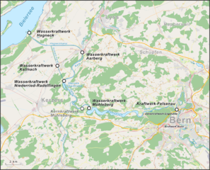
Deutsch: Lagekarte der Kraftwerke am Aarelauf zwischen Bern und Bielersee English: Loaction map of power plants along the river Aare between Bern and Lake Biel in Switzerland |
|||||||||
| Date | ||||||||||
| Source |
Own work Map was created using: |
|||||||||
| Creator | ||||||||||
| Permission (Reusing this file) |
Map data (c) OpenStreetMap (and) contributors, CC-BY-SA | |||||||||
| Geotemporal data | ||||||||||
| Bounding box |
|
|||||||||
| Georeferencing | ||||||||||
This file is licensed under the Creative Commons Attribution-Share Alike 2.0 Generic license.
- You are free:
- to share – to copy, distribute and transmit the work
- to remix – to adapt the work
- Under the following conditions:
- attribution – You must give appropriate credit, provide a link to the license, and indicate if changes were made. You may do so in any reasonable manner, but not in any way that suggests the licensor endorses you or your use.
- share alike – If you remix, transform, or build upon the material, you must distribute your contributions under the same or compatible license as the original.
File history
Click on a date/time to view the file as it appeared at that time.
| Date/Time | Thumbnail | Dimensions | User | Comment | |
|---|---|---|---|---|---|
| current | 02:30, 3 February 2015 | | 2,007 × 1,625 (2.08 MB) | Pechristener (talk | contribs) | {{Information |Description={{de|1=Lagekarte der Kraftwerke am Aarelauf zwischen Bern und Bielersee}}{{en|Loaction map of power plants along the river Aare between Bern and Lake Biel in Switzerland}} |Source ={{own}} Map was created using: *... |
You cannot overwrite this file.
File usage on Commons
There are no pages that use this file.
File usage on other wikis
The following other wikis use this file: