File:Konstanz Stadtteile mehrfarbig.png
Jump to navigation
Jump to search
Size of this preview: 523 × 600 pixels. Other resolutions: 209 × 240 pixels | 419 × 480 pixels | 880 × 1,009 pixels.
Original file (880 × 1,009 pixels, file size: 271 KB, MIME type: image/png)
Captions
Captions
Add a one-line explanation of what this file represents
| Description |
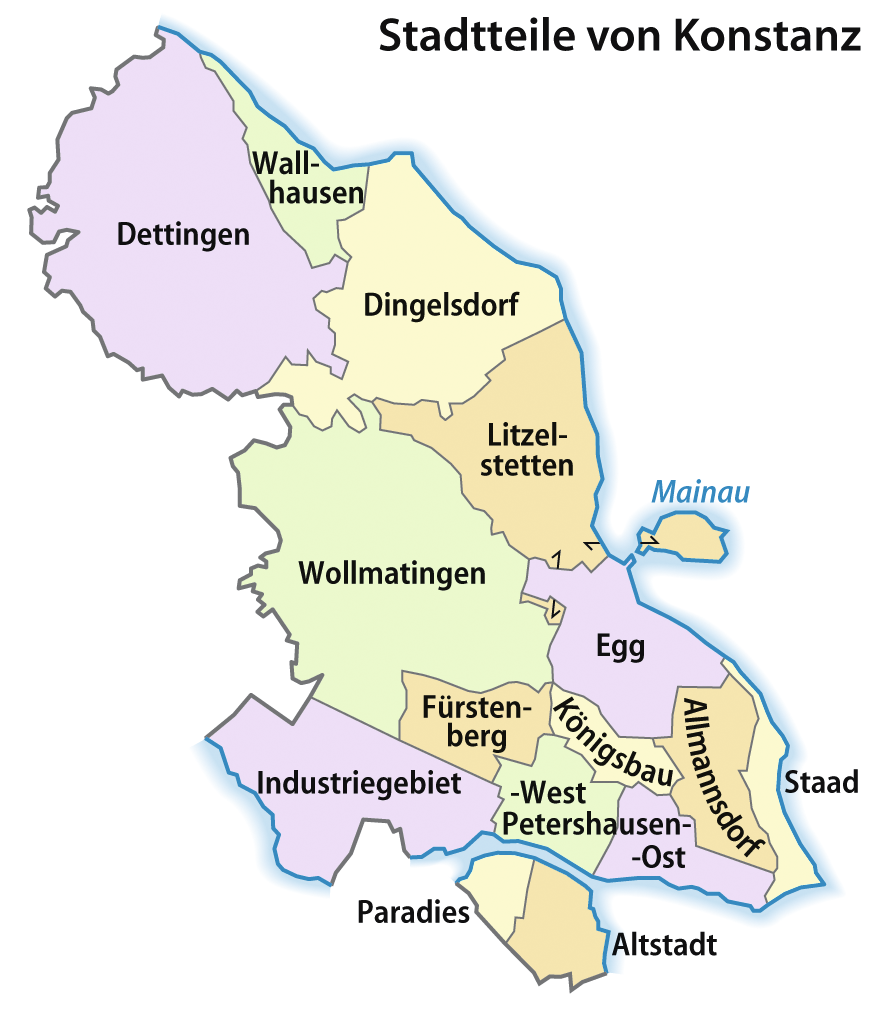
Deutsch: Karte der Stadtteile von Konstanz, mehrfarbige Version
English: Map of the boroughs of Konstanz, Germany |
| Date | 6 April 2009 (upload date) |
| Source | Own work |
| Author | NordNordWest |
| Other versions |
|


|
This map has been made or improved in the German Kartenwerkstatt (Map Lab). You can propose maps to improve as well.
|
Licensing
[edit]
I, the copyright holder of this work, hereby publish it under the following licenses:

|
Permission is granted to copy, distribute and/or modify this document under the terms of the GNU Free Documentation License, Version 1.2 or any later version published by the Free Software Foundation; with no Invariant Sections, no Front-Cover Texts, and no Back-Cover Texts. A copy of the license is included in the section entitled GNU Free Documentation License. |
| This file is licensed under the Creative Commons Attribution-Share Alike 3.0 Unported license. | ||
| ||
| This licensing tag was added to this file as part of the GFDL licensing update. |
You may select the license of your choice.
File history
Click on a date/time to view the file as it appeared at that time.
| Date/Time | Thumbnail | Dimensions | User | Comment | |
|---|---|---|---|---|---|
| current | 17:14, 6 April 2009 | | 880 × 1,009 (271 KB) | NordNordWest (talk | contribs) | {{Information |Description= {{de|Karte der Stadtteile von Konstanz, mehrfarbige Version}} {{en|Map of the boroughs of Konstanz, Germany}} |Source=self-made |Date=06-04-2009 |Author=NordNordWest |Per |
You cannot overwrite this file.
File usage on Commons
The following 13 pages use this file:
- Konstanz
- User:NordNordWest/Gallery/Maps
- File:Konstanz Stadtteile.png
- Category:Dingelsdorf
- Category:Egg (Konstanz)
- Category:Fürstenberg (Konstanz)
- Category:Konstanz
- Category:Maps of Konstanz
- Category:People of Konstanz
- Category:Petershausen (Konstanz)
- Category:Religion in Konstanz
- Category:Staad (Konstanz)
- Category:Wollmatingen
File usage on other wikis
The following other wikis use this file:
- Usage on ca.wikipedia.org
- Usage on de.wikipedia.org
- Usage on en.wikipedia.org
- Usage on gl.wikipedia.org
- Usage on hi.wikipedia.org
- Usage on hu.wikipedia.org
- Usage on ru.wikipedia.org
- Usage on sa.wikipedia.org
- Usage on sk.wikipedia.org
- Usage on sl.wikipedia.org
- Usage on sq.wikipedia.org
- Usage on te.wikipedia.org
- Usage on tt.wikipedia.org
- Usage on www.wikidata.org