File:Kolkheti1122.jpg
Jump to navigation
Jump to search

Size of this preview: 800 × 450 pixels. Other resolutions: 320 × 180 pixels | 640 × 360 pixels | 1,024 × 576 pixels | 1,600 × 900 pixels.
Original file (1,600 × 900 pixels, file size: 694 KB, MIME type: image/jpeg)
Captions
Captions
Add a one-line explanation of what this file represents
Summary
[edit]
| Description |
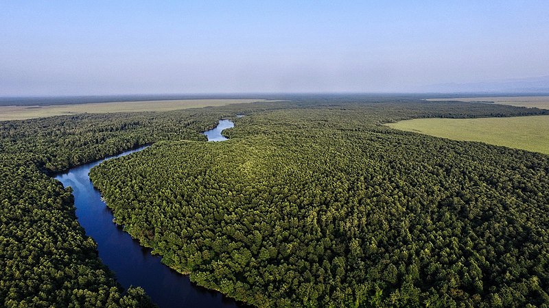
ქართული: კოლხეთის ეროვნული პარკი მდებარეობს დასავლეთ საქართველოში. იგი მოიცავს შავი ზღვის აღმოსავლეთ სანაპირო ზოლსა და პალიასტომის ტბის აუზს. ეროვნული პარკი კოლხეთის საერთაშორისო მნიშვნელობის მქონე ჭარბტენიანი ეკოსისტემების დაცვისა და შენარჩუნების მიზნითაა შექმნილი.
ეროვნული პარკის უბნები ხუთი ადმინისტრაციული რაიონის - ზუგდიდის, ხობის, სენაკის, აბაშისა და ლანჩხუთის ტერიტორიაზეა განლაგებული და საქართველოს ორი ისტორიული მხარის, სამეგრელოსა და გურიის ნაწილია. კოლხეთის ეროვნული პარკის ადმინისტრაცია ტურისტებს პალიასტომის ტბასა და მდ. ფიჩორის ხეობაში სანაოსნო ტურებს, ასევე სპორტულ თევზჭერას, ფრინველებზე დაკვირვებას (ბერდვოჩინგს) და ეკო-საგანმანათლებლო ტურებს სთავაზობს.English: Kolkheti National Park located in western Georgia. It includes the Black Sea coastline and the Paliastomi lake pool. The National Park is designed for the preservation and preservation of the ecosystems of international importance of Kolkheti. |
| Date | |
| Source | Own work |
| Author | Paata vardanashvili |
| Camera location | | View this and other nearby images on: OpenStreetMap |
|---|
Assessment
[edit]

|
This image won the 4th prize in the national contest of Georgia in Wiki Loves Earth 2018 Other languages:
|
This image was uploaded as part of Wiki Loves Earth 2018.
|
 |
Licensing
[edit]
I, the copyright holder of this work, hereby publish it under the following license:
This file is licensed under the Creative Commons Attribution-Share Alike 4.0 International license.
- You are free:
- to share – to copy, distribute and transmit the work
- to remix – to adapt the work
- Under the following conditions:
- attribution – You must give appropriate credit, provide a link to the license, and indicate if changes were made. You may do so in any reasonable manner, but not in any way that suggests the licensor endorses you or your use.
- share alike – If you remix, transform, or build upon the material, you must distribute your contributions under the same or compatible license as the original.
File history
Click on a date/time to view the file as it appeared at that time.
| Date/Time | Thumbnail | Dimensions | User | Comment | |
|---|---|---|---|---|---|
| current | 10:03, 25 June 2018 | | 1,600 × 900 (694 KB) | Paata vardanashvili (talk | contribs) | User created page with UploadWizard |
You cannot overwrite this file.
File usage on Commons
The following 4 pages use this file:
File usage on other wikis
The following other wikis use this file:
- Usage on az.wikipedia.org
- Usage on ba.wikipedia.org
- Usage on ceb.wikipedia.org
- Usage on cs.wikipedia.org
- Usage on da.wikipedia.org
- Usage on de.wikipedia.org
- Usage on de.wikivoyage.org
- Usage on en.wikipedia.org
- Usage on fa.wikipedia.org
- Usage on fr.wikipedia.org
- Usage on it.wikipedia.org
- Usage on it.wikivoyage.org
- Usage on ka.wikipedia.org
- Usage on ko.wikipedia.org
- Usage on lt.wikipedia.org
- Usage on mt.wikipedia.org
- Usage on pt.wikipedia.org
- Usage on ru.wikipedia.org
- Usage on sk.wikipedia.org
- Usage on sl.wikipedia.org
- Usage on sq.wikipedia.org
- Usage on th.wikipedia.org
- Usage on tr.wikipedia.org
- Usage on uk.wikipedia.org
- Usage on vi.wikipedia.org
- Usage on www.wikidata.org
- Usage on xmf.wikipedia.org
- Usage on zh.wikipedia.org