File:Koh administrative 1370 02.png
Jump to navigation
Jump to search

Size of this preview: 784 × 599 pixels. Other resolutions: 314 × 240 pixels | 628 × 480 pixels | 1,005 × 768 pixels | 1,228 × 939 pixels.
Original file (1,228 × 939 pixels, file size: 122 KB, MIME type: image/png)
Captions
Captions
Add a one-line explanation of what this file represents
Summary
[edit]
| Description |
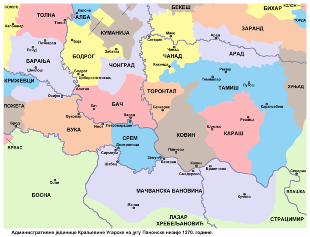
English: Administrative units of the Kingdom of Hungary in the southern Pannonian plain in 1370. Српски / srpski: Административне јединице Краљевине Угарске на југу Панонске низије 1370. године. |
| Date | |
| Source | Own work |
| Author | PANONIAN |
Licensing
[edit]
I, the copyright holder of this work, hereby publish it under the following license:
| This file is made available under the Creative Commons CC0 1.0 Universal Public Domain Dedication. | |
| The person who associated a work with this deed has dedicated the work to the public domain by waiving all of their rights to the work worldwide under copyright law, including all related and neighboring rights, to the extent allowed by law. You can copy, modify, distribute and perform the work, even for commercial purposes, all without asking permission.
|
References
[edit]
Borders in the map are made in accordance with this reference:
Secondary references:
- The Times History of Europe, Times Books, London, 2002.
- Istorijski atlas, Geokarta, Beograd, 1999.
- Zbornik "Vojvodina", knjiga I, Fototipsko izdanje, Prometej, Novi Sad, 2008.
- [1] - Géza Pálffy, IZVANREDAN IZVOR O ZEMLJOPISNIM ZNANJIMA UGARSKO-HRVATSKE POLITIČKE ELITE 16. STOLJEĆA.
File history
Click on a date/time to view the file as it appeared at that time.
| Date/Time | Thumbnail | Dimensions | User | Comment | |
|---|---|---|---|---|---|
| current | 16:47, 20 May 2015 | | 1,228 × 939 (122 KB) | PANONIAN (talk | contribs) | {{Information |Description ={{en|1=Administrative units of the Kingdom of Hungary in the southern Pannonian plain in 1370.}} |Source ={{own}} |Author =PANONIAN |Date =2015 |Permission = |other_versions... |
You cannot overwrite this file.
File usage on Commons
There are no pages that use this file.
File usage on other wikis
The following other wikis use this file:
- Usage on mk.wikipedia.org
- Usage on ru.wikipedia.org
- Usage on sl.wikipedia.org
- Usage on sr.wikipedia.org
- Банат
- Барања
- Срем
- Бачка
- Вршац
- Мачва
- Бачко-бодрошка жупанија
- Бачка жупанија
- Бодрошка жупанија
- Сремска жупанија
- Тамишка жупанија
- Торонталска жупанија
- Чонградска жупанија (бивша)
- Карашко-северинска жупанија
- Барањска жупанија (бивша)
- Мачванска бановина
- Карашка жупанија
- Куманија
- Вуковска жупанија
- Ковинска жупанија
- Чанадска жупанија
- Арадска жупанија
- Банат у средњем веку
- Дмитар Мрњавчевић
- Угарске жупаније
- Зарандска жупанија
Categories:
- Maps of 14th-century Serbia
- Maps of the history of Croatia in the Middle Ages
- Maps of the history of Romania in the Middle Ages
- Maps of the history of Hungary in the Late Middle Ages
- Maps of the history of Vojvodina
- Maps of the history of Bačka
- Maps of the history of Banat
- Maps of the history of Syrmia
- Maps of the history of Mačva
- Maps of the history of Baranja
- Serbian-language maps
- Csanád County
- Cenad, Timiș