File:Koeniglich Preussen.PNG
Jump to navigation
Jump to search
No higher resolution available.
Koeniglich_Preussen.PNG (686 × 540 pixels, file size: 103 KB, MIME type: image/png)
Captions
Captions
Add a one-line explanation of what this file represents
Summary
[edit]
| Description |
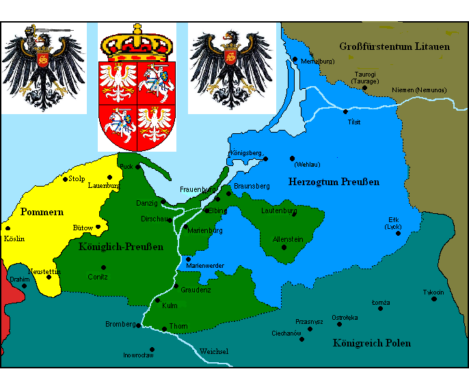
Deutsch: Karte Königlich-Preußens und der Nachbarstaaten in der Frühen Neuzeit
English: Map of Royal Prussia and surroundings in Early Modern Times
Polski: Mapa Prus Królewskich w czasie nowożytnym
Русский: Карта Королевской Пруссии и Прусского королевства в начале Нового времени |
| Source | http://pl.wikipedia.org/wiki/Grafika:Prusy_Krolewskie.PNG |
| Author | original map by Space Cadet, modified version by Historyk |
Licensing
[edit]

|
Permission is granted to copy, distribute and/or modify this document under the terms of the GNU Free Documentation License, Version 1.2 or any later version published by the Free Software Foundation; with no Invariant Sections, no Front-Cover Texts, and no Back-Cover Texts. A copy of the license is included in the section entitled GNU Free Documentation License. |
| This file is licensed under the Creative Commons Attribution-Share Alike 3.0 Unported license. | ||
| ||
| This licensing tag was added to this file as part of the GFDL licensing update. |
File history
Click on a date/time to view the file as it appeared at that time.
| Date/Time | Thumbnail | Dimensions | User | Comment | |
|---|---|---|---|---|---|
| current | 02:37, 2 November 2006 | | 686 × 540 (103 KB) | Ben-nb~commonswiki (talk | contribs) | == Summary == de: Karte Königlich-Preußens und der Nachbarstaaten in der Frühen Neuzeit en: Map of Royal Prussia and surroundings in Early Modern Times pl: Mapa Prus Królewskich w czasie nowożytnym Source: map of user Space Cadet (http://pl.wikipedi |
| 07:07, 26 April 2006 |  | 686 × 508 (99 KB) | Historyk~commonswiki (talk | contribs) | de: Karte Kłniglich-Preußens und der Nachbarstaaten in der Frühen Neuzeit en: Map of Royal Prussia and surroundings in Early Modern Times pl: Mapa Prus Królewskich w czasie nowożytnym Source: map of user Space Cadet (http://pl.wikipedia.org/wiki/Gra |
You cannot overwrite this file.
File usage on Commons
There are no pages that use this file.
File usage on other wikis
The following other wikis use this file:
- Usage on bat-smg.wikipedia.org
- Usage on be-tarask.wikipedia.org
- Usage on no.wikipedia.org
- Usage on ru.wikipedia.org