File:Klagenfurt Innere Stadt Alter Platz 1 Altes Rathaus 14072009 12.jpg
Jump to navigation
Jump to search

Size of this preview: 800 × 600 pixels. Other resolutions: 320 × 240 pixels | 640 × 480 pixels | 1,024 × 768 pixels | 1,280 × 960 pixels | 2,560 × 1,920 pixels | 3,328 × 2,496 pixels.
Original file (3,328 × 2,496 pixels, file size: 1.46 MB, MIME type: image/jpeg)
Captions
Captions
Add a one-line explanation of what this file represents
Summary
[edit]| Description |
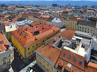
English: Aerial view (from the city parish church`s balcony of the bell tower) of the palace Rosenberg, former town hall on Alter Platz #1, inner city, Klagenfurt, Carinthia, Austria, EU
Deutsch: Blick vom Balkon des Stadtpfarrturms auf das Palais Rosenberg, Altes Rathaus am Alten Platz 1, Innere Stadt, Klagenfurt, Kärnten, Österreich, EU
|
||
| Date | |||
| Source | Own work | ||
| Author | Johann Jaritz | ||
| Permission (Reusing this file) |
I, the copyright holder of this work, hereby publish it under the following licenses:
This file is licensed under the Creative Commons Attribution-Share Alike 4.0 International license.
You may select the license of your choice. |

| Object location | | View this and other nearby images on: OpenStreetMap |
|---|
Licensing
[edit]Johann Jaritz, the copyright holder of this work, hereby publishes it under the following license:
This file is licensed under the Creative Commons Attribution-Share Alike 4.0 International license.
Attribution: Johann Jaritz / CC BY-SA 4.0
- You are free:
- to share – to copy, distribute and transmit the work
- to remix – to adapt the work
- Under the following conditions:
- attribution – You must give appropriate credit, provide a link to the license, and indicate if changes were made. You may do so in any reasonable manner, but not in any way that suggests the licensor endorses you or your use.
- share alike – If you remix, transform, or build upon the material, you must distribute your contributions under the same or compatible license as the original.
Modifications
[edit]|
|
Please do not upload a modified image here without consultation with the Author. The author would like to make corrections only at his own source. This ensures that the changes are preserved. |

File history
Click on a date/time to view the file as it appeared at that time.
| Date/Time | Thumbnail | Dimensions | User | Comment | |
|---|---|---|---|---|---|
| current | 07:12, 17 July 2009 | | 3,328 × 2,496 (1.46 MB) | Johann Jaritz (talk | contribs) | {{Information |Description={{en|1=View at the town hall, the Alter Platz and the old Inner City of Carinthian`s capital Klagenfurt on the Lake Woerth, Carinthia, Austria}} {{de|1=Blick auf das Alte Rathaus, den Alten Platz und die Innere Stadt der Landesh |
You cannot overwrite this file.
File usage on Commons
The following 2 pages use this file:
File usage on other wikis
The following other wikis use this file:
- Usage on de.wikipedia.org