File:Kirstenbosch-023.jpg
Jump to navigation
Jump to search

Size of this preview: 800 × 533 pixels. Other resolutions: 320 × 213 pixels | 640 × 427 pixels | 1,024 × 683 pixels | 1,280 × 853 pixels | 2,560 × 1,707 pixels | 3,211 × 2,141 pixels.
Original file (3,211 × 2,141 pixels, file size: 5.02 MB, MIME type: image/jpeg)
Captions
Captions
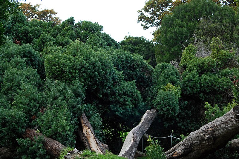
Podocarpus elongatus tree recovering from storm damage after some assistance by botanical garden personnel
Summary
[edit]
| Description |
Podocarpus elongatus (Ait.) L'Herit. ex Pers. Afrikaans: Vier stamme van 'n enkele Breëriviergeelhout, die sogenaamde "towerboom" van Kirstenbosch Nasionale Botaniese Tuin, 6½ jaar nadat dit op 1 November 2005 deur stormsterk wind omgewaai is. Die wind het etlike takke afgeskeur, die boom in twee stukke gebreek en die wortels blootgelê. Eerder as om dit op te kap soos die nabye Breëriviergeelhout wat reeds in 1984 omgewaai is, het die personeel die onstabiele stamme van die publiek afgesper. Die kroon is dan gesnoei, sommige takke ondersteun en die blootgestelde wortels is met grond bedek en gereeld bewater. Pas-blootgestelde dele van die baldakyn het aanvanklik tekens van sonbrand getoon, maar kort voor lank het lote oral uit die blootgestelde stamme gespruit. Hierdie spesie beskik naamlik oor die vermoë om deur epikormiese uitlopers te herstel.[1]
English: Four stems of a single Breede River yellowwood, the so-called "magic tree" of Kirstenbosch National Botanical Gardens, 6½ years after it was blown down by gale force wind on November 1, 2005. The wind tore several branches off, broke the tree into two parts and exposed the roots. Not giving up this time as they did with the nearby con-specific that was blown down in 1984, the staff cordoned it of from the public because of its instability. The crown was then pruned, the boughs braced and the exposed roots covered with soil and regularly watered. Newly exposed parts of the canopy initially showed signs of sunburn, but shortly shoots appeared all over the exposed trunks, as this species is known to recover by resprouting from epicormic buds.
|
| Date | |
| Source |
|
| Author | Harvey Barrison from Massapequa, NY, USA |
| Camera location | | View this and other nearby images on: OpenStreetMap |
|---|
Licensing
[edit]
This file is licensed under the Creative Commons Attribution-Share Alike 2.0 Generic license.
- You are free:
- to share – to copy, distribute and transmit the work
- to remix – to adapt the work
- Under the following conditions:
- attribution – You must give appropriate credit, provide a link to the license, and indicate if changes were made. You may do so in any reasonable manner, but not in any way that suggests the licensor endorses you or your use.
- share alike – If you remix, transform, or build upon the material, you must distribute your contributions under the same or compatible license as the original.
| This image, originally posted to Flickr, was reviewed on 19 September 2012 by the administrator or reviewer File Upload Bot (Magnus Manske), who confirmed that it was available on Flickr under the stated license on that date. |
File history
Click on a date/time to view the file as it appeared at that time.
| Date/Time | Thumbnail | Dimensions | User | Comment | |
|---|---|---|---|---|---|
| current | 20:11, 19 September 2012 | | 3,211 × 2,141 (5.02 MB) | File Upload Bot (Magnus Manske) (talk | contribs) | Transferred from Flickr by User:Elitre |
You cannot overwrite this file.
File usage on Commons
The following page uses this file:
- File:Cape Town 2012 05 14 0217 (7179915457).jpg (file redirect)
.jpg&redirect=no)