File:Kinross geograph-3724013-by-Ben-Brooksbank.jpg
Jump to navigation
Jump to search

Size of this preview: 800 × 540 pixels. Other resolutions: 320 × 216 pixels | 640 × 432 pixels | 1,024 × 692 pixels | 1,280 × 865 pixels | 2,392 × 1,616 pixels.
Original file (2,392 × 1,616 pixels, file size: 3.24 MB, MIME type: image/jpeg)
Captions
Captions
Add a one-line explanation of what this file represents
Summary
[edit]
| Description |
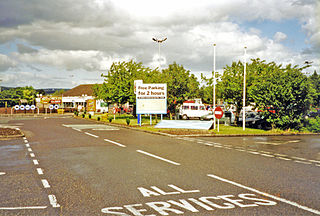
English: Approaching Kinross Services on M90, 2002 - site of Kinross Junction station. View northward, towards Perth: ex-NBR Edinburgh etc. - Dunfermline - Perth main line, junction of the Devon Valley line from Alloa. Nothing remains here of the railways, because the station was closed 5/1/70 along with the line Cowdenbeath - Perth (goods continued Kelty - Milnathort until 4/5/70), the line from Alloa having been closed to passengers from 15/6/64 and to goods up to 1973. Subsequently the M90 motorway was built for many miles on the course of the railway to Perth. |
| Date | |
| Source | From geograph.org.uk |
| Author | Ben Brooksbank |
| Permission (Reusing this file) |
Creative Commons Attribution Share-alike license 2.0 |
| Attribution (required by the license) | Ben Brooksbank / Approaching Kinross Services on M90, 2002 - site of Kinross Junction station / |
| Camera location | | View this and other nearby images on: OpenStreetMap |
|---|
Licensing
[edit]

|
This image was taken from the Geograph project collection. See this photograph's page on the Geograph website for the photographer's contact details. The copyright on this image is owned by Ben Brooksbank and is licensed for reuse under the Creative Commons Attribution-ShareAlike 2.0 license.
|
This file is licensed under the Creative Commons Attribution-Share Alike 2.0 Generic license.
Attribution: Ben Brooksbank
- You are free:
- to share – to copy, distribute and transmit the work
- to remix – to adapt the work
- Under the following conditions:
- attribution – You must give appropriate credit, provide a link to the license, and indicate if changes were made. You may do so in any reasonable manner, but not in any way that suggests the licensor endorses you or your use.
- share alike – If you remix, transform, or build upon the material, you must distribute your contributions under the same or compatible license as the original.
File history
Click on a date/time to view the file as it appeared at that time.
| Date/Time | Thumbnail | Dimensions | User | Comment | |
|---|---|---|---|---|---|
| current | 15:06, 5 December 2013 | | 2,392 × 1,616 (3.24 MB) | Chevin (talk | contribs) | == {{int:filedesc}} == {{Information |Description={{en|1='''Approaching Kinross Services on M90, 2002 - site of Kinross Junction station.'''<br/> View northward, towards Perth: ex-NBR Edinburgh etc. - Dunfermline - Perth main line, junction of the Devo... |
You cannot overwrite this file.
File usage on Commons
There are no pages that use this file.
File usage on other wikis
The following other wikis use this file:
- Usage on en.wikipedia.org