File:Kingdom of Italy 1942 with provinces.svg
Jump to navigation
Jump to search

Size of this PNG preview of this SVG file: 510 × 600 pixels. Other resolutions: 204 × 240 pixels | 408 × 480 pixels | 653 × 768 pixels | 871 × 1,024 pixels | 1,742 × 2,048 pixels | 3,360 × 3,950 pixels.
Original file (SVG file, nominally 3,360 × 3,950 pixels, file size: 930 KB)
Captions
Captions
Add a one-line explanation of what this file represents
Summary
[edit]
| Description |
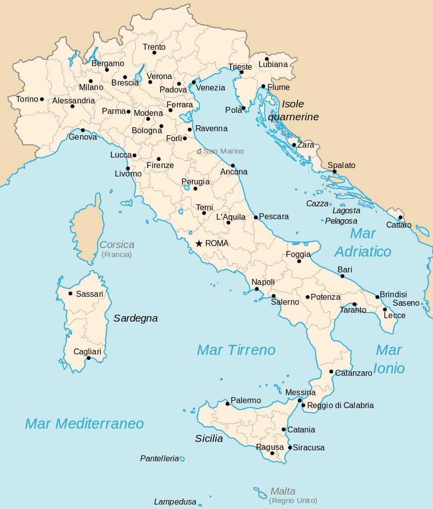
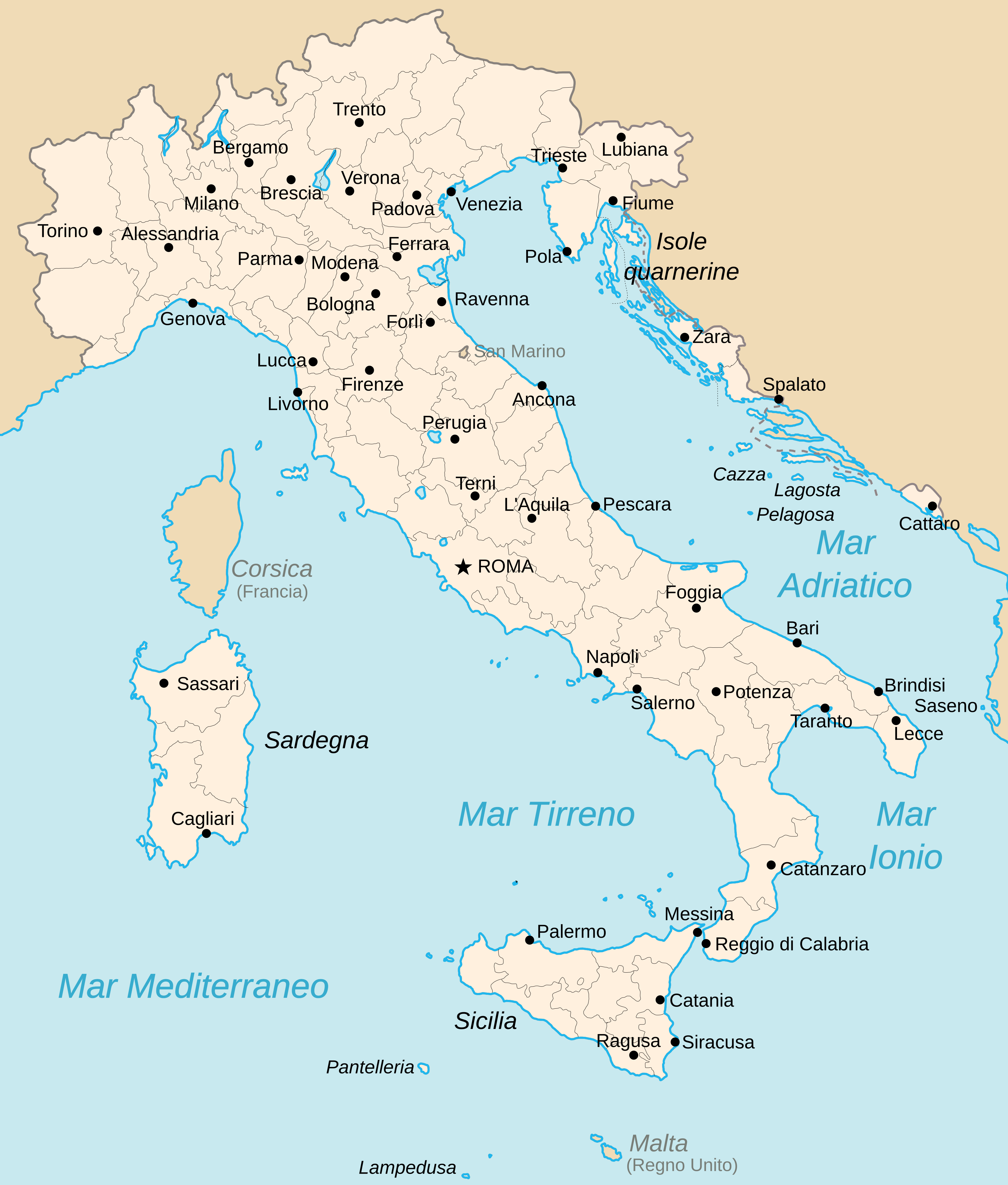
English: map of the Kingdom of Italy (Regno d'Italia) in 1942 with provinces.
Italiano: cartina del Regno d'Italia nel 1942 con le province. |
| Date | |
| Source | Own work, original from Derivative works of this file: Kingdom of Italy 1919 map.svg |
| Author | Gigillo83 |
Licensing
[edit]
I, the copyright holder of this work, hereby publish it under the following licenses:

|
Permission is granted to copy, distribute and/or modify this document under the terms of the GNU Free Documentation License, Version 1.2 or any later version published by the Free Software Foundation; with no Invariant Sections, no Front-Cover Texts, and no Back-Cover Texts. A copy of the license is included in the section entitled GNU Free Documentation License. |
This file is licensed under the Creative Commons Attribution 3.0 Unported license.
- You are free:
- to share – to copy, distribute and transmit the work
- to remix – to adapt the work
- Under the following conditions:
- attribution – You must give appropriate credit, provide a link to the license, and indicate if changes were made. You may do so in any reasonable manner, but not in any way that suggests the licensor endorses you or your use.
You may select the license of your choice.
File history
Click on a date/time to view the file as it appeared at that time.
| Date/Time | Thumbnail | Dimensions | User | Comment | |
|---|---|---|---|---|---|
| current | 10:59, 21 December 2011 | | 3,360 × 3,950 (930 KB) | Gigillo83 (talk | contribs) | Fix province Spalato and Fiume |
| 10:06, 22 June 2011 |  | 3,360 × 3,950 (924 KB) | Gigillo83 (talk | contribs) | + some isles | |
| 16:18, 21 June 2011 |  | 3,360 × 3,950 (920 KB) | Gigillo83 (talk | contribs) | fix | |
| 16:14, 21 June 2011 |  | 3,360 × 3,950 (920 KB) | Gigillo83 (talk | contribs) | - regions, + Cattaro and Dalmazia | |
| 13:42, 16 June 2011 |  | 3,360 × 3,950 (894 KB) | Gigillo83 (talk | contribs) | fix | |
| 13:41, 16 June 2011 |  | 3,360 × 3,950 (894 KB) | Gigillo83 (talk | contribs) | - OR, - IS, -CE | |
| 17:46, 15 June 2011 |  | 3,360 × 3,950 (896 KB) | Gigillo83 (talk | contribs) | - IS | |
| 16:23, 15 June 2011 |  | 3,360 × 3,950 (896 KB) | Gigillo83 (talk | contribs) | == Summary == {{Information |Description={{en|map of the Kingdom of Italy (Regno d'Italia) in 1942 with provinces.}} {{it|cartina del Regno d'Italia nel 1942 con le province.}} |Source={{own}}, original from {{DerivativeVersions|Kingdom of Italy 1919 map. |
You cannot overwrite this file.
File usage on Commons
The following page uses this file:
.svg)
File usage on other wikis
The following other wikis use this file:
- Usage on be-tarask.wikipedia.org
- Usage on be.wikipedia.org
- Usage on bg.wikipedia.org
- Usage on bs.wikipedia.org
- Usage on ca.wikipedia.org
- Usage on cs.wikipedia.org
- Usage on cv.wikipedia.org
- Usage on en.wikipedia.org
- Usage on eo.wikipedia.org
- Usage on fo.wikipedia.org
- Usage on gl.wikipedia.org
- Usage on id.wikipedia.org
- Usage on is.wikipedia.org
- Usage on it.wikipedia.org
- Usage on jv.wikipedia.org
- Usage on lt.wikipedia.org
- Usage on pl.wikipedia.org
- Usage on pt.wikipedia.org
- Usage on ro.wikipedia.org
- Usage on sh.wikipedia.org
- Usage on sv.wikipedia.org
- Usage on ug.wikipedia.org
- Usage on uk.wikipedia.org
- Usage on ur.wikipedia.org
- Usage on uz.wikipedia.org
- Usage on wuu.wikipedia.org
- Usage on zh-yue.wikipedia.org