File:King James Bridge, Omagh - geograph.org.uk - 537072.jpg
Jump to navigation
Jump to search
No higher resolution available.
King_James_Bridge,_Omagh_-_geograph.org.uk_-_537072.jpg (640 × 480 pixels, file size: 64 KB, MIME type: image/jpeg)
Captions
Captions
Add a one-line explanation of what this file represents
Summary
[edit]
| Description |
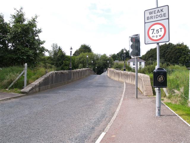
English: King James Bridge, Omagh. Viewed from the Irishtown side. The bridge tapers to a single narrow lane at the middle and there are draw-in "V"s on either side to allow pedestrians to wait until traffic passes. Up until the 70s there wasn't any traffic lights for the traffic which lead to disputes between motorists who thought that they had the right of way from their direction. |
| Date | |
| Source | From geograph.org.uk |
| Author | Kenneth Allen |
| Attribution (required by the license) | Kenneth Allen / King James Bridge, Omagh / |
| Camera location | | View this and other nearby images on: OpenStreetMap |
|---|
_heading:225.00&language=en)
| Object location | | View this and other nearby images on: OpenStreetMap |
|---|
_heading:225.00&language=en)
Licensing
[edit]

|
This image was taken from the Geograph project collection. See this photograph's page on the Geograph website for the photographer's contact details. The copyright on this image is owned by Kenneth Allen and is licensed for reuse under the Creative Commons Attribution-ShareAlike 2.0 license.
|
This file is licensed under the Creative Commons Attribution-Share Alike 2.0 Generic license.
Attribution: Kenneth Allen
- You are free:
- to share – to copy, distribute and transmit the work
- to remix – to adapt the work
- Under the following conditions:
- attribution – You must give appropriate credit, provide a link to the license, and indicate if changes were made. You may do so in any reasonable manner, but not in any way that suggests the licensor endorses you or your use.
- share alike – If you remix, transform, or build upon the material, you must distribute your contributions under the same or compatible license as the original.
File history
Click on a date/time to view the file as it appeared at that time.
| Date/Time | Thumbnail | Dimensions | User | Comment | |
|---|---|---|---|---|---|
| current | 20:14, 5 February 2011 | | 640 × 480 (64 KB) | GeographBot (talk | contribs) | == {{int:filedesc}} == {{Information |description={{en|1=King James Bridge, Omagh Viewed from the Irishtown side. The bridge tapers to a single narrow lane at the middle and there are draw-in "V"s on either side to allow pedestrians to wait until traffic |
You cannot overwrite this file.
File usage on Commons
There are no pages that use this file.