File:Kildin Saami map.JPG
Kildin_Saami_map.JPG (299 × 242 pixels, file size: 32 KB, MIME type: image/jpeg)
Captions
Captions
Summary
[edit]| Description |
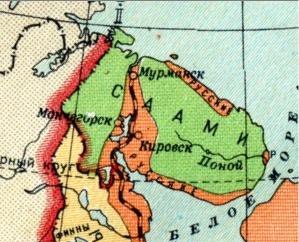
Русский: Карта распространения саамского языка на Кольском полуострове
English: Map of distribution of the Saami languages in the Kola Peninsula. Green is Saami, Yelllow is Karelian, Red is Russian. |
| Date | |
| Source |
This file was derived from: Ethnic map USSR 1941.jpg |
| Author |

Licensing
[edit]
This file is a Ukrainian or Ukrainian SSR work and it is presently in the public domain in Ukraine, because it was published before January 1, 1954, and the creator (if known) died before that date (details).
|
 |
This work is in the public domain in Russia according to article 1281 of the Civil Code of the Russian Federation, articles 5 and 6 of Law No. 231-FZ of the Russian Federation of December 18, 2006 (the Implementation Act for Book IV of the Civil Code of the Russian Federation).
This usually means that one of the following conditions is fulfilled.
This work is in the public domain in the United States, because it was in the public domain in its home country (Russia) on the URAA date (January 1, 1996), and it wasn't re-published for 30 days following initial publications in the U.S. [1] If the author of this work was subjected to repression and rehabilitated posthumously, copyright term is counted from January 1 of the year following the year of rehabilitation.
|
|||||
File history
Click on a date/time to view the file as it appeared at that time.
| Date/Time | Thumbnail | Dimensions | User | Comment | |
|---|---|---|---|---|---|
| current | 07:20, 12 September 2012 | | 299 × 242 (32 KB) | Insider (talk | contribs) | crop: best fit |
| 09:05, 3 September 2009 |  | 299 × 409 (40 KB) | João Q. (talk | contribs) | {{Information |Description={{en|1=Map of distribution of the Kildin Saami language in the Kola Peninsula}} |Source=Own work by uploader |Author=João Q. |Date= |Permission= |other_versions=Карта распрост |
You cannot overwrite this file.
File usage on Commons
The following page uses this file:
File usage on other wikis
The following other wikis use this file:
- Usage on azb.wikipedia.org
- Usage on cs.wikipedia.org
- Usage on el.wikipedia.org
- Usage on en.wikipedia.org
- Usage on fr.wikipedia.org
- Usage on ka.wikipedia.org
- Usage on kv.wikipedia.org
- Usage on ru.wikipedia.org
- Usage on sr.wikipedia.org