File:Kiebitzberg.JPG
Jump to navigation
Jump to search

Size of this preview: 800 × 533 pixels. Other resolutions: 320 × 213 pixels | 640 × 427 pixels | 1,024 × 683 pixels | 1,280 × 853 pixels | 2,400 × 1,600 pixels.
Original file (2,400 × 1,600 pixels, file size: 2.27 MB, MIME type: image/jpeg)
Captions
Captions
Add a one-line explanation of what this file represents
Summary
[edit]
| Description |
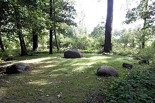
Deutsch: Der Kiebitzberg im Hermann-Löns-Park, nordöstlich des Annateiches. Der von kleineren Findlingen umgebene zentrale Findling ist ein mittel- bis grobkörniger, rötlicher Granit aus Småland. 1,6 × 1,1 × 0,9 m. Er war laut Beschilderung im Park seit 1938 als Naturdenkmal in der Zuständigkeit der Stadt Hannover geschützt. Die Region Hannover führt den Findling nicht mehr als Naturdenkmal, sondern als Geotop (Geotop-Nr. 3624/03) |
| Date | |
| Source | Own work |
| Author | Den man tau |
| Camera location | | View this and other nearby images on: OpenStreetMap |
|---|
Licensing
[edit]
I, the copyright holder of this work, hereby publish it under the following license:
This file is licensed under the Creative Commons Attribution-Share Alike 4.0 International license.
- You are free:
- to share – to copy, distribute and transmit the work
- to remix – to adapt the work
- Under the following conditions:
- attribution – You must give appropriate credit, provide a link to the license, and indicate if changes were made. You may do so in any reasonable manner, but not in any way that suggests the licensor endorses you or your use.
- share alike – If you remix, transform, or build upon the material, you must distribute your contributions under the same or compatible license as the original.
File history
Click on a date/time to view the file as it appeared at that time.
| Date/Time | Thumbnail | Dimensions | User | Comment | |
|---|---|---|---|---|---|
| current | 20:15, 9 August 2015 | | 2,400 × 1,600 (2.27 MB) | Den man tau (talk | contribs) | User created page with UploadWizard |
You cannot overwrite this file.
File usage on Commons
There are no pages that use this file.