File:Kharkiv Oblast Control Evolution.png
Jump to navigation
Jump to search

Size of this preview: 653 × 599 pixels. Other resolutions: 262 × 240 pixels | 523 × 480 pixels | 837 × 768 pixels | 1,200 × 1,101 pixels.
Original file (1,200 × 1,101 pixels, file size: 257 KB, MIME type: image/png)
Captions
Captions
Add a one-line explanation of what this file represents

|
File:Russian Occupation of Kharkiv Oblast.svg is a vector version of this file. It should be used in place of this PNG file when not inferior.
File:Kharkiv Oblast Control Evolution.png → File:Russian Occupation of Kharkiv Oblast.svg
For more information, see Help:SVG. |
 |
Summary
[edit]| Description |
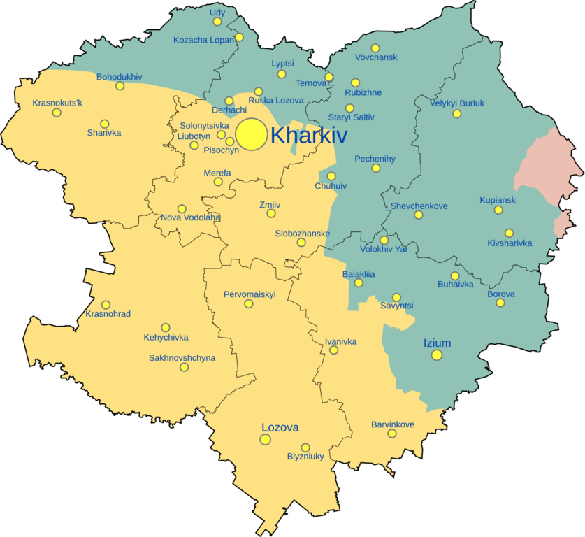
English: Kharkiv oblast situation as of 9th September 2022
yellow - Ukrainian control, red - Russian control, blue - formerly under by Russian control |
| Date | |
| Source | Own work |
| Author | FanousekCZSK |
| Other versions |
[]
|


.png)


.png)


Licensing
[edit]
I, the copyright holder of this work, hereby publish it under the following license:
This file is licensed under the Creative Commons Attribution-Share Alike 4.0 International license.
- You are free:
- to share – to copy, distribute and transmit the work
- to remix – to adapt the work
- Under the following conditions:
- attribution – You must give appropriate credit, provide a link to the license, and indicate if changes were made. You may do so in any reasonable manner, but not in any way that suggests the licensor endorses you or your use.
- share alike – If you remix, transform, or build upon the material, you must distribute your contributions under the same or compatible license as the original.
File history
Click on a date/time to view the file as it appeared at that time.
| Date/Time | Thumbnail | Dimensions | User | Comment | |
|---|---|---|---|---|---|
| current | 17:00, 23 April 2023 | | 1,200 × 1,101 (257 KB) | Nahabino (talk | contribs) | Update per ISW |
| 14:17, 30 January 2023 |  | 1,200 × 1,101 (257 KB) | Arabik4892 (talk | contribs) | Reverted to version as of 12:27, 1 December 2022 (UTC) | |
| 00:48, 7 December 2022 |  | 1,200 × 1,101 (257 KB) | Nahabino (talk | contribs) | Update per ISW | |
| 12:27, 1 December 2022 |  | 1,200 × 1,101 (257 KB) | Arabik4892 (talk | contribs) | Reverted to version as of 23:21, 13 October 2022 (UTC) | |
| 22:17, 25 November 2022 |  | 1,200 × 1,101 (257 KB) | Nahabino (talk | contribs) | Update per ISW | |
| 23:06, 20 November 2022 |  | 1,200 × 1,101 (257 KB) | Nahabino (talk | contribs) | Update per ISW | |
| 22:32, 12 November 2022 |  | 1,200 × 1,101 (257 KB) | Nahabino (talk | contribs) | Update per ISW | |
| 20:47, 31 October 2022 |  | 1,200 × 1,101 (257 KB) | Nahabino (talk | contribs) | Update per ISW | |
| 21:11, 26 October 2022 |  | 1,200 × 1,101 (257 KB) | Nahabino (talk | contribs) | Update per ISW | |
| 23:00, 19 October 2022 |  | 1,200 × 1,101 (257 KB) | Nahabino (talk | contribs) | Update per ISW |
You cannot overwrite this file.
File usage on Commons
The following 81 pages use this file:
- Ukraine Regional Occupation Maps
- User:Jcornelius/Angola/2022 December 1-10
- User:Jcornelius/Angola/2022 November 11-20
- User:Jcornelius/Angola/2022 November 21-30
- User:Jcornelius/Angola/2022 October 1-10
- User:Jcornelius/Angola/2022 October 11-20
- User:Jcornelius/Angola/2022 October 21-31
- User:Jcornelius/Angola/2022 September 1-10
- User:Jcornelius/Angola/2022 September 11-20
- User:Jcornelius/Angola/2022 September 21-30
- User:Jcornelius/Angola/2023 January 21-31
- User:Magog the Ogre/Maps of conflicts/2022 December
- User:Magog the Ogre/Maps of conflicts/2022 November
- User:Magog the Ogre/Maps of conflicts/2022 October
- User:Magog the Ogre/Maps of conflicts/2022 September
- User:Magog the Ogre/Maps of conflicts/2023 April
- User:Magog the Ogre/Maps of conflicts/2023 January
- User:Minorax/SVG available/2022 December 1-6
- User:Minorax/SVG available/2022 December 7-12
- User:Minorax/SVG available/2022 November 19-24
- User:Minorax/SVG available/2022 November 25-30
- User:Minorax/SVG available/2022 November 7-12
- User:Minorax/SVG available/2022 October 1-6
- User:Minorax/SVG available/2022 October 13-18
- User:Minorax/SVG available/2022 October 19-24
- User:Minorax/SVG available/2022 October 25-31
- User:Minorax/SVG available/2022 October 7-12
- User:Minorax/SVG available/2023 April 19-24
- User:Minorax/SVG available/2023 January 25-31
- User:ביקורת/Rabbis/2022 December 7
- User:ביקורת/Rabbis/2023 January 30
- File:Dnipropetrovsk-poltava oblast occupation.png
- File:Dnipropetrovsk Oblast border skirmishes.png
- File:Kharkiv Oblast Control Evolution.png
- File:Kherson military–civilian administration.png
- File:Kherson military–civilian administration hatched.svg
- File:Occupation of Mykolaiv Oblast by Russia (With Cities).png
- File:Poltava oblast border skirmishes.png
- File:Russian Occupation of Chernihiv Oblast.svg
- File:Russian Occupation of Crimea.svg
- File:Russian Occupation of Dnipropetrovsk & Poltava Oblasts.svg
- File:Russian Occupation of Dnipropetrovsk Oblast.svg
- File:Russian Occupation of Donetsk Oblast.svg
- File:Russian Occupation of Kharkiv Oblast.svg
- File:Russian Occupation of Kherson Oblast.svg
- File:Russian Occupation of Kyiv Oblast.png
- File:Russian Occupation of Kyiv Oblast.svg
- File:Russian Occupation of Mykolaiv Oblast.svg
- File:Russian Occupation of Poltava Oblast.svg
- File:Russian Occupation of Sumy Oblast.svg
- File:Russian Occupation of Zaporizhzhia Oblast.svg
- File:Russian Occupation of Zhytomyr Oblast.svg
- File:Russian occupation of Chernihiv Oblast.png
- File:Russian occupation of Chernihiv Oblast peak.png
- File:Russian occupation of Donetsk Oblast.png
- File:Russian occupation of Kharkiv Oblast.png
- File:Russian occupation of Luhansk Oblast.png
- File:Russian occupation of Luhansk Oblast.svg
- File:Russian occupation of Mykolaiv Oblast.png
- File:Russian occupation of Sumy Oblast.png
- File:Russian occupation of Zhytomyr Oblast.png
- File:Zaporizhzhia frontline.png
- File:Zaporizhzhia military–civilian administration hatched.svg
- File:Zaporizhzhia region.png
- File:Днепропетровская область.png
- File:Донецкая область или Донецкая народная Республика.png
- File:Житомирская область.png
- File:Запорожская область.png
- File:Карта звільнених територій Житомирської області.png
- File:Киев.png
- File:Киевская область.png
- File:Крым (Автономная Республика).png
- File:Луганская область или Луганская Народная Республика.png
- File:Николаевская область 2.png
- File:Одесская область 2.png
- File:Полтавская область.png
- File:Севастополь.png
- File:Сумская область.png
- File:Харьковская область 2.png
- File:Херсонская область.png
- File:Черниговская область 2.png
File usage on other wikis
The following other wikis use this file:
- Usage on be.wikipedia.org
- Usage on el.wikipedia.org
- Usage on fr.wikipedia.org
- Usage on li.wikinews.org
- Usage on sl.wikipedia.org
- Usage on www.wikidata.org