File:Kexby Bridge - geograph.org.uk - 910738.jpg
Jump to navigation
Jump to search
Size of this preview: 444 × 599 pixels. Other resolutions: 178 × 240 pixels | 474 × 640 pixels.
Original file (474 × 640 pixels, file size: 124 KB, MIME type: image/jpeg)
Captions
Captions
Add a one-line explanation of what this file represents
This is a photo of listed building number 1316288. |
Summary
[edit]
| Description |
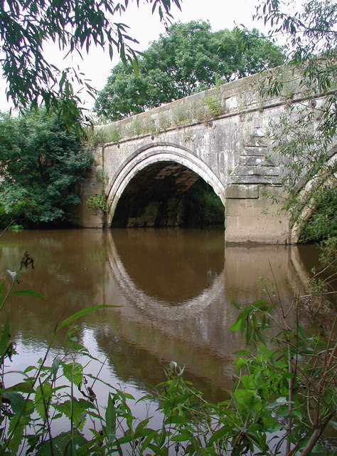
English: Kexby Bridge over the River Derwent forming the boundary between North Yorkshire and the East Riding of Yorkshire, England. Three arched stone road bridge over the River Derwent at Kexby. A stone bridge was recorded here in the 1420s, built by York merchant Nicholas Blackburn, although a ferry belonging to the lord of Kexby also operated as late as 1650. An inscription on the current bridge claims that it was built in 1650 although it may incorporate bits of an older structure, and considerable sums of money were spent repairing and possibly improving it between 1778 and 1788. A new bridge was built to the north in the 1960s bypassing the old one. The small village of Kexby is thought to have been hit hard by the Black Death as it was excused from paying about 60% of its tax quota in 1354. More about the history of Kexby can be found at British History Online. http://www.british-history.ac.uk/report.aspx?compid=23020 |
| Date | |
| Source | From geograph.org.uk |
| Author | Paul Glazzard |
| Permission (Reusing this file) |
Creative Commons Attribution Share-alike license 2.0 |
| Attribution (required by the license) | Paul Glazzard / Kexby Bridge / |
| Camera location | | View this and other nearby images on: OpenStreetMap |
|---|
_heading:270.00&language=en)
| Object location | | View this and other nearby images on: OpenStreetMap |
|---|
_heading:270.00&language=en)
Licensing
[edit]

|
This image was taken from the Geograph project collection. See this photograph's page on the Geograph website for the photographer's contact details. The copyright on this image is owned by Paul Glazzard and is licensed for reuse under the Creative Commons Attribution-ShareAlike 2.0 license.
|
This file is licensed under the Creative Commons Attribution-Share Alike 2.0 Generic license.
Attribution: Paul Glazzard
- You are free:
- to share – to copy, distribute and transmit the work
- to remix – to adapt the work
- Under the following conditions:
- attribution – You must give appropriate credit, provide a link to the license, and indicate if changes were made. You may do so in any reasonable manner, but not in any way that suggests the licensor endorses you or your use.
- share alike – If you remix, transform, or build upon the material, you must distribute your contributions under the same or compatible license as the original.
File history
Click on a date/time to view the file as it appeared at that time.
| Date/Time | Thumbnail | Dimensions | User | Comment | |
|---|---|---|---|---|---|
| current | 23:13, 21 February 2011 | | 474 × 640 (124 KB) | GeographBot (talk | contribs) | == {{int:filedesc}} == {{Information |description={{en|1=Kexby Bridge Three arched stone road bridge over the River Derwent at Kexby. A stone bridge was recorded here in the 1420s, built by York merchant Nicholas Blackburn, although a ferry belonging to t |
You cannot overwrite this file.
File usage on Commons
There are no pages that use this file.
File usage on other wikis
The following other wikis use this file:
- Usage on en.wikipedia.org