File:Kempten historische Flurkarte 01.png
Jump to navigation
Jump to search

Size of this preview: 800 × 459 pixels. Other resolutions: 320 × 184 pixels | 640 × 367 pixels | 1,024 × 587 pixels | 1,473 × 845 pixels.
Original file (1,473 × 845 pixels, file size: 3.36 MB, MIME type: image/png)
Captions
Captions
Add a one-line explanation of what this file represents
Summary
[edit]
| Description |
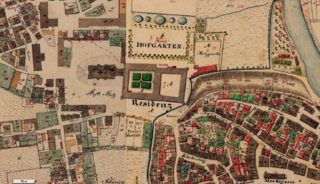
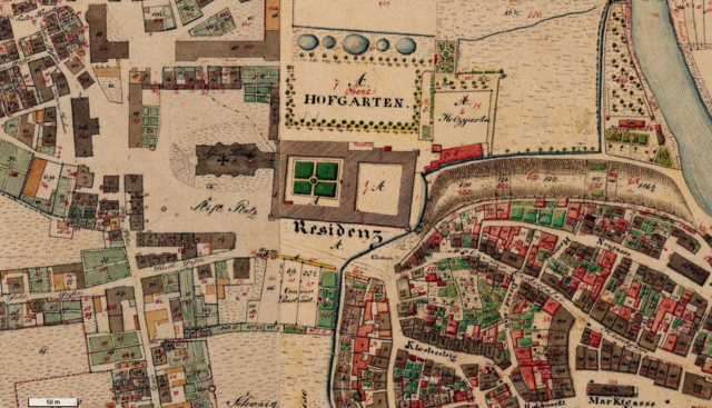
Deutsch: historische Flurkarte: Kempten, Hildegardplatz (damals Stifts Platz) und Umgebung |
| Date | between circa 1820 and circa 1860 |
| Source | http://geoportal.bayern.de/bayernatlas/?lon=4373508.0&lat=5289134.0&zoom=13&base=952 |
| Author | Königlich Bayerisches Vermessungsamt? |
Licensing
[edit]
|
This work is in the public domain in its country of origin and other countries and areas where the copyright term is the author's life plus 100 years or fewer. | |
| This file has been identified as being free of known restrictions under copyright law, including all related and neighboring rights. | |
File history
Click on a date/time to view the file as it appeared at that time.
| Date/Time | Thumbnail | Dimensions | User | Comment | |
|---|---|---|---|---|---|
| current | 11:25, 1 March 2013 | | 1,473 × 845 (3.36 MB) | Renamed user 09876576 (talk | contribs) | Reverted to version as of 09:19, 26 February 2013 |
| 11:24, 1 March 2013 |  | 245 × 433 (258 KB) | Renamed user 09876576 (talk | contribs) | anderer Ausschnitt | |
| 09:19, 26 February 2013 |  | 1,473 × 845 (3.36 MB) | Ratzer (talk | contribs) | {{Information |Description ={{de|1=historische Flurkarte: Kempten, Hildegardplatz (damals Stifts Platz) und Umgebung}} |Source =http://geoportal.bayern.de/bayernatlas/?lon=4373508.0&lat=5289134.0&zoom=13&base=952 |Author =Königlich ... |
You cannot overwrite this file.
File usage on Commons
There are no pages that use this file.
File usage on other wikis
The following other wikis use this file:
- Usage on de.wikipedia.org