File:Kelston Round Hill seen from Cley Hill - geograph.org.uk - 934590.jpg
Jump to navigation
Jump to search

Size of this preview: 800 × 591 pixels. Other resolutions: 320 × 236 pixels | 640 × 473 pixels | 1,024 × 757 pixels | 1,280 × 946 pixels | 2,676 × 1,977 pixels.
Original file (2,676 × 1,977 pixels, file size: 2.6 MB, MIME type: image/jpeg)
Captions
Captions
Add a one-line explanation of what this file represents
Summary
[edit]| Description |
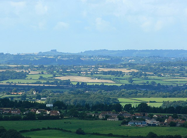
English: Kelston Round Hill seen from Cley Hill Distance 16.5 miles. Kelston Tump, as it is called locally is on the skyline to the left, Prospect Stile and Lansdown are to the right of it. It is just possible to see the transmitter mast at the racecourse on the far right. |
| Date | |
| Source | From geograph.org.uk |
| Author | Maurice Pullin |
| Attribution (required by the license) | Maurice Pullin / 2008 : West of north from Cley Hill / |
| Camera location | | View this and other nearby images on: OpenStreetMap |
|---|
| Object location | | View this and other nearby images on: OpenStreetMap |
|---|
Licensing
[edit]
|
This image was taken from the Geograph project collection. See this photograph's page on the Geograph website for the photographer's contact details. The copyright on this image is owned by Maurice Pullin and is licensed for reuse under the Creative Commons Attribution-ShareAlike 2.0 license.
|
This file is licensed under the Creative Commons Attribution-Share Alike 2.0 Generic license.
Attribution: Maurice Pullin
- You are free:
- to share – to copy, distribute and transmit the work
- to remix – to adapt the work
- Under the following conditions:
- attribution – You must give appropriate credit, provide a link to the license, and indicate if changes were made. You may do so in any reasonable manner, but not in any way that suggests the licensor endorses you or your use.
- share alike – If you remix, transform, or build upon the material, you must distribute your contributions under the same or compatible license as the original.

_heading:337.00&language=en)
_heading:337.00&language=en)
File history
Click on a date/time to view the file as it appeared at that time.
| Date/Time | Thumbnail | Dimensions | User | Comment | |
|---|---|---|---|---|---|
| current | 10:12, 15 July 2018 | | 2,676 × 1,977 (2.6 MB) | Geograph Update Bot (talk | contribs) | Higher-resolution version from Geograph. |
| 06:47, 22 February 2011 |  | 640 × 473 (59 KB) | GeographBot (talk | contribs) | == {{int:filedesc}} == {{Information |description={{en|1=Kelston Round Hill seen from Cley Hill Distance 16.5 miles. Kelston Tump, as it is called locally is on the skyline to the left, Prospect Stile and Lansdown are to the right of it. It is just possib |
You cannot overwrite this file.
File usage on Commons
There are no pages that use this file.