File:Kavkazy topografi os.svg
Jump to navigation
Jump to search

Size of this PNG preview of this SVG file: 800 × 392 pixels. Other resolutions: 320 × 157 pixels | 640 × 313 pixels | 1,024 × 501 pixels | 1,280 × 626 pixels | 2,560 × 1,253 pixels | 805 × 394 pixels.
Original file (SVG file, nominally 805 × 394 pixels, file size: 3.83 MB)
Captions
Captions
Add a one-line explanation of what this file represents
Summary
[edit]
| Description |
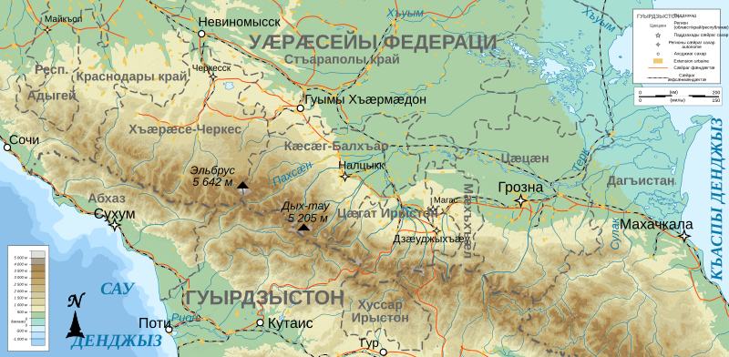
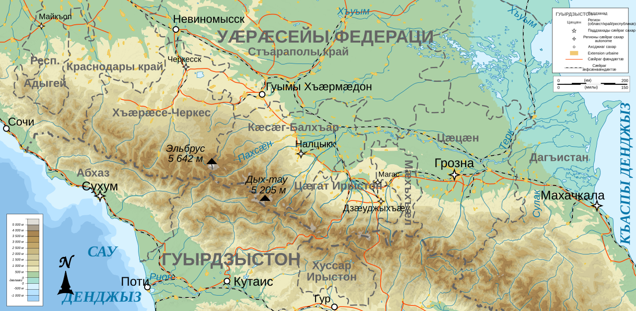
Deutsch: Topographische Karte von Nordkaukasus, osetische Version English: Topographic map in Ossetic of North Caucasus Français : Carte topographique en ossete de la Ciscaucasie avec les républiques autonomes (balkanisation du Caucase) Ирон: Кавказы топографион картæ иронау |
| Date | (UTC) |
| Source | |
| Author |
|
I, the copyright holder of this work, hereby publish it under the following licenses:
This file is licensed under the Creative Commons Attribution-Share Alike 3.0 Unported, 2.5 Generic, 2.0 Generic and 1.0 Generic license.
- You are free:
- to share – to copy, distribute and transmit the work
- to remix – to adapt the work
- Under the following conditions:
- attribution – You must give appropriate credit, provide a link to the license, and indicate if changes were made. You may do so in any reasonable manner, but not in any way that suggests the licensor endorses you or your use.
- share alike – If you remix, transform, or build upon the material, you must distribute your contributions under the same or compatible license as the original.

|
Permission is granted to copy, distribute and/or modify this document under the terms of the GNU Free Documentation License, Version 1.2 or any later version published by the Free Software Foundation; with no Invariant Sections, no Front-Cover Texts, and no Back-Cover Texts. A copy of the license is included in the section entitled GNU Free Documentation License. |
You may select the license of your choice.
Original upload log
[edit]
This image is a derivative work of the following images:
- File:North_Caucasus_topographic_map-fr.svg licensed with Cc-by-sa-3.0,2.5,2.0,1.0, GFDL
- 2008-11-09T17:27:58Z Bourrichon 805x394 (4080363 Bytes)
- 2008-11-08T16:42:13Z Bourrichon 805x394 (4079121 Bytes) == Summary == {{Information |Description={{de|Topographische Karte von [[:de:Nordkaukasus|Nordkaukasus]], französische Version}}{{en|Topographic map in French of [[:en:North Caucasus|North Caucasus]]}}{{fr|Carte topographiqu
Uploaded with derivativeFX
Licensing
[edit]
This file is licensed under the Creative Commons Attribution-Share Alike 3.0 Unported license.
- You are free:
- to share – to copy, distribute and transmit the work
- to remix – to adapt the work
- Under the following conditions:
- attribution – You must give appropriate credit, provide a link to the license, and indicate if changes were made. You may do so in any reasonable manner, but not in any way that suggests the licensor endorses you or your use.
- share alike – If you remix, transform, or build upon the material, you must distribute your contributions under the same or compatible license as the original.
File history
Click on a date/time to view the file as it appeared at that time.
| Date/Time | Thumbnail | Dimensions | User | Comment | |
|---|---|---|---|---|---|
| current | 12:58, 10 July 2022 | | 805 × 394 (3.83 MB) | Taamu (talk | contribs) | Correcting names |
| 01:31, 20 January 2020 |  | 805 × 394 (3.89 MB) | Takhirgeran Umar (talk | contribs) | clarification | |
| 01:00, 10 April 2010 |  | 805 × 394 (3.89 MB) | Amikeco (talk | contribs) | {{Information |Description={{de|Topographische Karte von Nordkaukasus, osetische Version}}{{en|Topographic map in Ossetic of North Caucasus}}{{fr|Carte topographique en ossete de la [[:fr:Ciscaucasie|Ciscaucasie |
You cannot overwrite this file.
File usage on Commons
There are no pages that use this file.
File usage on other wikis
The following other wikis use this file:
- Usage on os.wikipedia.org