File:Kaurnaland.png
Jump to navigation
Jump to search
No higher resolution available.
Kaurnaland.png (444 × 499 pixels, file size: 52 KB, MIME type: image/png)
Captions
Captions
Add a one-line explanation of what this file represents
Summary
[edit]
| Description |
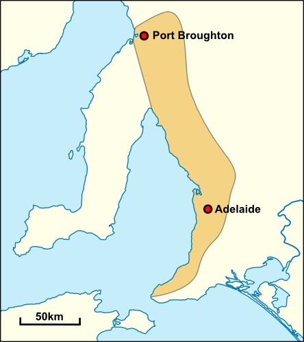
English: Approximate extent of the traditional territory of the Kaurna people. Based on the description given by Robert Amery in Warrabarna Kaurna!: reclaiming an Australian language. |
| Date | |
| Source | Own work based on: Australia South Australia location map.svg |
| Author | Yeti Hunter (talk) |
Licensing
[edit]
Yeti Hunter at English Wikipedia, the copyright holder of this work, hereby publishes it under the following licenses:
This file is licensed under the Creative Commons Attribution-Share Alike 3.0 Unported license.
Attribution: Yeti Hunter at English Wikipedia
- You are free:
- to share – to copy, distribute and transmit the work
- to remix – to adapt the work
- Under the following conditions:
- attribution – You must give appropriate credit, provide a link to the license, and indicate if changes were made. You may do so in any reasonable manner, but not in any way that suggests the licensor endorses you or your use.
- share alike – If you remix, transform, or build upon the material, you must distribute your contributions under the same or compatible license as the original.

|
Permission is granted to copy, distribute and/or modify this document under the terms of the GNU Free Documentation License, Version 1.2 or any later version published by the Free Software Foundation; with no Invariant Sections, no Front-Cover Texts, and no Back-Cover Texts. A copy of the license is included in the section entitled GNU Free Documentation License. |
You may select the license of your choice.
Original upload log
[edit]
The original description page was here. All following user names refer to en.wikipedia.
- 2010-01-15 07:41 Yeti Hunter 444×499× (53150 bytes) Shading some islands that I missed first time
- 2010-01-15 06:19 Yeti Hunter 444×499× (54451 bytes) Fixing map - adding Kangaroo Island
- 2010-01-15 06:11 Yeti Hunter 444×499× (48515 bytes) {{Information |Description = Approximate extent of the traditional territory of the Kaurna people. Based on the description given by Robert Amery in ''Warrabarna Kaurna!: reclaiming an Australian language''. Map based on [[File:Australia South Austral
File history
Click on a date/time to view the file as it appeared at that time.
| Date/Time | Thumbnail | Dimensions | User | Comment | |
|---|---|---|---|---|---|
| current | 15:57, 5 May 2019 | | 444 × 499 (52 KB) | OgreBot (talk | contribs) | (BOT): Uploading old version of file from en.wikipedia; originally uploaded on 2010-01-15 07:41:28 by Yeti Hunter |
| 15:57, 5 May 2019 |  | 444 × 499 (53 KB) | OgreBot (talk | contribs) | (BOT): Uploading old version of file from en.wikipedia; originally uploaded on 2010-01-15 06:19:33 by Yeti Hunter | |
| 15:57, 5 May 2019 |  | 444 × 499 (47 KB) | OgreBot (talk | contribs) | (BOT): Uploading old version of file from en.wikipedia; originally uploaded on 2010-01-15 06:11:21 by Yeti Hunter |
You cannot overwrite this file.
File usage on Commons
The following page uses this file:
- File:محدوده ی تقریبی قلمرو بومان کارنا.png (file redirect)
File usage on other wikis
The following other wikis use this file: