File:Katmai National Park, Alaska.jpg
Jump to navigation
Jump to search

Size of this preview: 800 × 533 pixels. Other resolutions: 320 × 213 pixels | 640 × 427 pixels | 1,024 × 683 pixels | 1,280 × 853 pixels | 3,000 × 2,000 pixels.
Original file (3,000 × 2,000 pixels, file size: 4.67 MB, MIME type: image/jpeg)
Captions
Captions
Add a one-line explanation of what this file represents
Summary
[edit]
| Description |
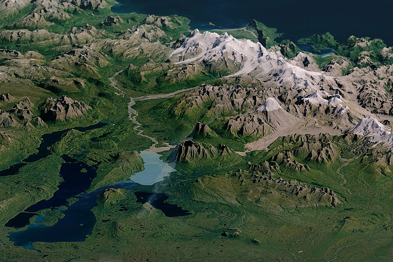
English: Natural-colour image of Katmai National Park with the Landsat data overlaid on a digital elevation model (created with data from the ASTER instrument on NASA’s Terra satellite). The model gives a three-dimensional sense of the landscape. |
| Date | |
| Source | NASA Earth Observatory |
| Author | NASA |
Licensing
[edit]
| This file is in the public domain in the United States because it was solely created by NASA. NASA copyright policy states that "NASA material is not protected by copyright unless noted". (See Template:PD-USGov, NASA copyright policy page or JPL Image Use Policy.) | ||
 |
Warnings:
|
| Annotations | This image is annotated: View the annotations at Commons |
File history
Click on a date/time to view the file as it appeared at that time.
| Date/Time | Thumbnail | Dimensions | User | Comment | |
|---|---|---|---|---|---|
| current | 11:16, 15 May 2016 | | 3,000 × 2,000 (4.67 MB) | Originalwana (talk | contribs) | {{Information |Description ={{en|1=Natural-colour image of Katmai National Park with the Landsat data overlaid on a digital elevation model (created with data from the ASTER instrument on NASA’s Terra satellite). The model gives a three-dimensiona... |
You cannot overwrite this file.
File usage on Commons
The following 2 pages use this file:
File usage on other wikis
The following other wikis use this file:
- Usage on en.wikipedia.org
- Usage on vi.wikipedia.org