File:KatmaiNP L5 03sep95.jpg
From Wikimedia Commons, the free media repository
Jump to navigation
Jump to search
KatmaiNP_L5_03sep95.jpg (540 × 540 pixels, file size: 96 KB, MIME type: image/jpeg)
File information
Structured data
Captions
Captions
Add a one-line explanation of what this file represents
Summary
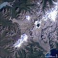
[edit]| DescriptionKatmaiNP L5 03sep95.jpg | Satellite image of the Valley of Ten Thousand Smokes and surrounding area in w:Katmai National Park and Preserve, Alaska, USA. |
| Date | |
| Source | http://earthobservatory.nasa.gov/Newsroom/NewImages/images.php3?img_id=17007 |
| Author | Jesse Allen, NASA Earth Observatory, using data obtained from the University of Maryland’s Global Land Cover Facility. |
| Permission (Reusing this file) |
Public domain. |
| Other versions | Larger, uncropped, unannotated version available from source URL. |
Licensing
[edit]| Public domainPublic domainfalsefalse |
| This file is in the public domain in the United States because it was solely created by NASA. NASA copyright policy states that "NASA material is not protected by copyright unless noted". (See Template:PD-USGov, NASA copyright policy page or JPL Image Use Policy.) |  | |
 |
Warnings:
|
File history
Click on a date/time to view the file as it appeared at that time.
| Date/Time | Thumbnail | Dimensions | User | Comment | |
|---|---|---|---|---|---|
| current | 16:52, 8 May 2006 |  | 540 × 540 (96 KB) | Holly Cheng (talk | contribs) | {{Information | Description=Satellite image of the Valley of Ten Thousand Smokes and surrounding area in w:Katmai National Park and Preserve, Alaska, USA. | Source=http://earthobservatory.nasa.gov/Newsroom/NewImages/images.php3?img_id=17007 | Date=Sep |
You cannot overwrite this file.
File usage on Commons
There are no pages that use this file.
File usage on other wikis
The following other wikis use this file:
- Usage on en.wikipedia.org
- Usage on es.wikipedia.org
- Usage on fr.wikipedia.org
- Usage on he.wikipedia.org
- Usage on it.wikipedia.org
- Usage on ja.wikipedia.org
- Usage on ko.wikipedia.org
- Usage on nl.wikipedia.org
- Usage on zh.wikipedia.org
Metadata
This file contains additional information such as Exif metadata which may have been added by the digital camera, scanner, or software program used to create or digitize it. If the file has been modified from its original state, some details such as the timestamp may not fully reflect those of the original file. The timestamp is only as accurate as the clock in the camera, and it may be completely wrong.
| _error | 0 |
|---|
Categories:
- Landsat images of the United States
- Satellite pictures of mountains
- Satellite pictures of Alaska
- Mount Katmai
- Novarupta
- Mount Mageik
- Satellite pictures of volcanoes in the United States
- Katmai Caldera
- Mount Griggs
- Mount Martin (Alaska)
- Valley of Ten Thousand Smokes
- Volcanoes in Alaska in 1995
- Sandur in Alaska
- Satellite pictures of Katmai National Park
Hidden category:
