File:Kath Pfarrkirche hl Johannes Nepomuk in Trabenreith 02 2015-09.jpg
Original file (4,800 × 3,200 pixels, file size: 5.83 MB, MIME type: image/jpeg)
Captions
Summary
[edit]DescriptionKath Pfarrkirche hl Johannes Nepomuk in Trabenreith 02 2015-09.jpg |
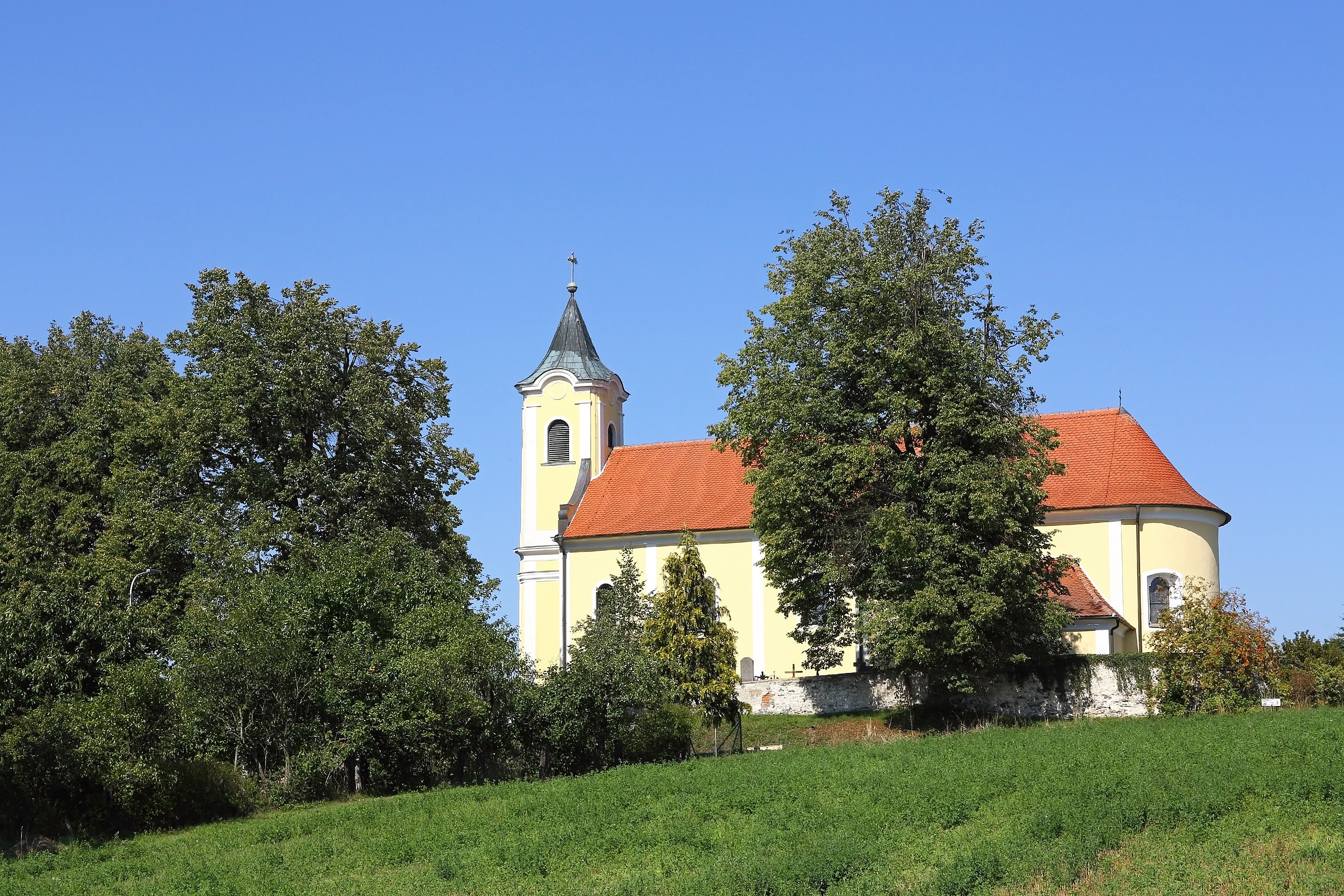
Deutsch: Die erhöht am Nordrand des Ortes gelegene und von einer Mauer umgebene Pfarrkirche hl. Johannes Nepomuk ist eine spätbarocke Saalkirche mit Westturm. Die fünf Winterlinden an der Südseite des Friedhofs wurden 1967 zum Naturdenkmal erklärt. |
Date | |
Source | Own work |
Author | Duke of W4 |
Camera location | 48° 45′ 37.77″ N, 15° 34′ 22.23″ E | View this and other nearby images on: OpenStreetMap | 48.760493; 15.572842 |
---|
Licensing
[edit]- You are free:
- to share – to copy, distribute and transmit the work
- to remix – to adapt the work
- Under the following conditions:
- attribution – You must give appropriate credit, provide a link to the license, and indicate if changes were made. You may do so in any reasonable manner, but not in any way that suggests the licensor endorses you or your use.
- share alike – If you remix, transform, or build upon the material, you must distribute your contributions under the same or compatible license as the original.
This image was uploaded as part of Wiki Loves Monuments 2015.
Afrikaans ∙ Alemannisch ∙ azərbaycanca ∙ Bahasa Indonesia ∙ Bahasa Melayu ∙ Bikol Central ∙ bosanski ∙ brezhoneg ∙ català ∙ čeština ∙ Cymraeg ∙ dansk ∙ davvisámegiella ∙ Deutsch ∙ eesti ∙ English ∙ español ∙ Esperanto ∙ euskara ∙ français ∙ Frysk ∙ Gaeilge ∙ galego ∙ hrvatski ∙ Ido ∙ italiano ∙ latviešu ∙ Lëtzebuergesch ∙ Malagasy ∙ magyar ∙ Malti ∙ Nederlands ∙ norsk ∙ norsk nynorsk ∙ norsk bokmål ∙ polski ∙ português ∙ português do Brasil ∙ română ∙ shqip ∙ sicilianu ∙ slovenčina ∙ slovenščina ∙ suomi ∙ svenska ∙ Tagalog ∙ Türkçe ∙ Yorùbá ∙ Zazaki ∙ Ελληνικά ∙ беларуская ∙ беларуская (тарашкевіца) ∙ български ∙ кыргызча ∙ македонски ∙ русский ∙ српски / srpski ∙ українська ∙ ქართული ∙ հայերեն ∙ नेपाली ∙ हिन्दी ∙ বাংলা ∙ മലയാളം ∙ ไทย ∙ 한국어 ∙ +/− |
File history
Click on a date/time to view the file as it appeared at that time.
Date/Time | Thumbnail | Dimensions | User | Comment | |
---|---|---|---|---|---|
current | 10:52, 13 September 2015 | 4,800 × 3,200 (5.83 MB) | Duke of W4 (talk | contribs) | User created page with UploadWizard |
You cannot overwrite this file.
File usage on Commons
There are no pages that use this file.
File usage on other wikis
The following other wikis use this file:
- Usage on de.wikipedia.org
Metadata
This file contains additional information such as Exif metadata which may have been added by the digital camera, scanner, or software program used to create or digitize it. If the file has been modified from its original state, some details such as the timestamp may not fully reflect those of the original file. The timestamp is only as accurate as the clock in the camera, and it may be completely wrong.
Camera manufacturer | Canon |
---|---|
Camera model | Canon EOS 6D |
Author | Duke of W4 |
Copyright holder |
|
Exposure time | 1/320 sec (0.003125) |
F-number | f/18 |
ISO speed rating | 640 |
Date and time of data generation | 13:37, 12 September 2015 |
Lens focal length | 59 mm |
Latitude | 48° 45′ 37.77″ N |
Longitude | 15° 34′ 22.23″ E |
Altitude | 576.6 meters above sea level |
Orientation | Normal |
Horizontal resolution | 350 dpi |
Vertical resolution | 350 dpi |
Software used | Adobe Photoshop Elements 8.0 Windows |
File change date and time | 12:29, 13 September 2015 |
Y and C positioning | Centered |
Exif version | 2.3 |
Date and time of digitizing | 13:37, 12 September 2015 |
Meaning of each component |
|
APEX shutter speed | 8.375 |
APEX aperture | 8.375 |
APEX exposure bias | 0.33333333333333 |
Flash | Flash did not fire, compulsory flash suppression |
Supported Flashpix version | 1 |
Color space | sRGB |
Focal plane X resolution | 3,810.5849582173 |
Focal plane Y resolution | 3,815.89958159 |
Focal plane resolution unit | inches |
Custom image processing | Normal process |
Exposure mode | Auto exposure |
White balance | Manual white balance |
Scene capture type | Standard |
GPS time (atomic clock) | 11:37 |
Reference for direction of image | True direction |
Direction of image | 345.14 |
Geodetic survey data used | WGS-84 |
Latitude destination | 48° 45′ 41.33″ N |
Longitude of destination | 15° 34′ 20.8″ E |
GPS date | 12 September 2015 |
GPS tag version | 0.0.2.2 |
Supported Flashpix version | 1 |
Image width | 4,800 px |
Image height | 3,200 px |
Date metadata was last modified | 14:29, 13 September 2015 |
Unique ID of original document | xmp.did:CBC59F38EB59E511A8FEAECE6137D42F |
IIM version | 20,179 |
Structured data
Items portrayed in this file
depicts
12 September 2015
48°45'37.77494"N, 15°34'22.23160"E
0.003125 second
18
59 millimetre
640
image/jpeg
- Cultural heritage monuments in Austria with known IDs
- Cultural heritage monuments in Austria missing SDC location of creation
- Natural monuments in Austria with known ID
- Files with coordinates missing SDC location of creation
- CC-BY-SA-4.0
- Self-published work
- Images from Wiki Loves Monuments 2015
- Images from Wiki Loves Monuments 2015 in Austria
- Images from Wiki Loves Monuments missing SDC location of creation
- Cultural heritage monuments in Austria check done
- Uploaded via Campaign:wlm-at
- Austria photographs taken on 2015-09-12
- Pages with maps