File:Katas Raj Temples LRMEXPORT13291344123387720200425172341270.jpg

Original file (6,368 × 3,232 pixels, file size: 7 MB, MIME type: image/jpeg)
Captions
Captions
Summary
[edit]
| Description |
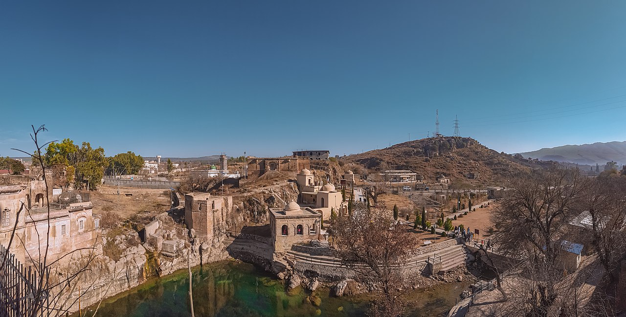
English: The Katas Raj Temples, is a complex of several Hindu temples connected to one another by walkways & surrounded by a pond named Katas, regarded as sacred by Hindus. Temples are located at an altitude of 2,000 feet, with area covering about 260 kanals. Its history dates back to 200-300 years BC. According to references, it is the place where Alberuni attempted to measure the circumference of the Earth.
Located near Kallar Kahar interchange, Potohar Plateau near the town of Choa Saidanshah, District Chakwal, Punjab, Pakistan. Facts 1. The name "Katas Raj"is believed to be derived from the Sanskrit word kataksha, meaning "tearful eyes." Originally referred to as Viskund, or "poison spring", but was later referred to as Amarkund & finally Katakshkund, meaning "Spring of tearful eyes." Take a bath in this Holy Pond of Tears & your sins will wash away. 2. In "Puranas (religious text)"; the pond have been created from shed of two tears of Lord Shiva, as He flew across the sky carrying the dead body of His wife Sati. One creating this pond, the other falling & making a pond in Ajmer, Rajasthan. Pond occupies an area of atleast 2 kanals with a maximum depth of 20 feet. 3. It is the second biggest holy place in Punjab for Hindu pioneers after Jawala Mukhi. In Mahābhārata; temples are traditionally believed to be the site where Pandava brothers spent 12 years (in exile) & assembled the sanctuaries of Satghara, also engaged in a riddle contest with the Yakshas. Another tradition states that the Hindu deity Krishna laid the foundation & established a hand-made Shiva linga. 4. Its a popular pilgrimage site for Hindus. Guru Nanak, is believed to have visited, . Ranjit Singh also regularly performed pilgrimage. He visited the site for the Vaisakhi festival. 5. The site houses the Satgraha, a group of seven ancient temples, remains of a Buddhist stupa, five other medieval temples & havelis. 6. Architecture: i) The Ramachandra Mandir; is a double-storied structure has eight rooms & a staircase at the south leading to the first floor. Has two jharokas (balconies). ii) The Hanuman Mandir; is on the western side of a high rectangular enclosure with entrances on the south & the north. The temple's ceiling is lime-plastered. iii) The Shiva temple: built on a square platform. Its entrance is a recessed round arch with faint cusps & a rectangular opening to the north. iv) Hari Singh Nalwa's Fort & haveli; was built during the reign of Hari Singh Nalwa, for his use as a fort & residence. Located on a small hillock & overlooks the entire temple complex. |
| Date | |
| Source | Own work |
| Author | Shahzaib Damn Cruze |
Licensing
[edit]
- You are free:
- to share – to copy, distribute and transmit the work
- to remix – to adapt the work
- Under the following conditions:
- attribution – You must give appropriate credit, provide a link to the license, and indicate if changes were made. You may do so in any reasonable manner, but not in any way that suggests the licensor endorses you or your use.
- share alike – If you remix, transform, or build upon the material, you must distribute your contributions under the same or compatible license as the original.
File history
Click on a date/time to view the file as it appeared at that time.
| Date/Time | Thumbnail | Dimensions | User | Comment | |
|---|---|---|---|---|---|
| current | 12:46, 6 May 2020 | | 6,368 × 3,232 (7 MB) | Shahzaib Damn Cruze (talk | contribs) | Uploaded own work with UploadWizard |
You cannot overwrite this file.
File usage on Commons
There are no pages that use this file.