File:Kartvelian peoples untill the VI century BC-ka.png
Jump to navigation
Jump to search

Size of this preview: 800 × 535 pixels. Other resolutions: 320 × 214 pixels | 640 × 428 pixels | 1,024 × 685 pixels | 1,280 × 856 pixels | 2,000 × 1,338 pixels.
Original file (2,000 × 1,338 pixels, file size: 804 KB, MIME type: image/png)
Captions
Captions
Add a one-line explanation of what this file represents
Summary
[edit]
| Description |
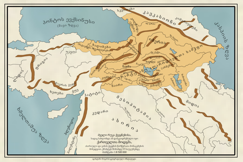
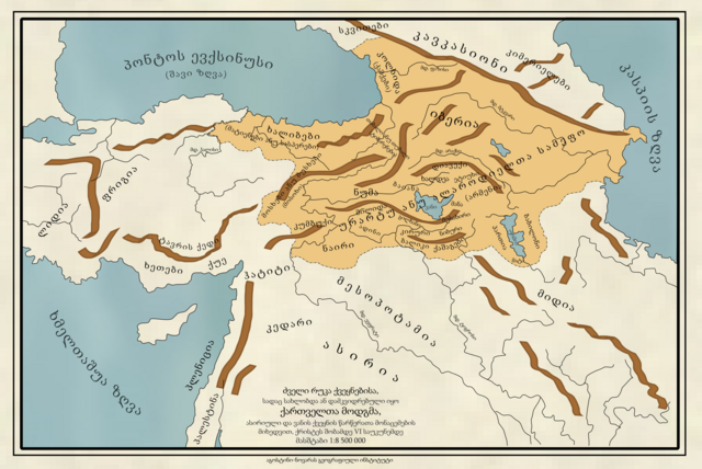
English: Map of the countries where Kartvelian peoples were settled or living untill the VI century BC. According to the data from Assyrian and Van Country scripts.
Scale 1:8 500 000 Credits: Geographic Institute Agustín Codazzi / Geographic Institute Of Novaraქართული: ძველი რუკა ქვეყნებისა, სადაც სახლობდა ან დამკვიდრებული იყო ქართველთა მოდგმა, ასირიული და ვანის ქვეყნის წარწერათა მონაცემების მიხედვით, ქრისტეს შობამდე VI საუკუნემდე
მასშტაბი 1:8 500 000 აგოსტინის გეოგრაფიული ინსტიტუტი, ნოვარა |
| Date | |
| Source | Own work |
| Author | User:Ercwlff |
Licensing
[edit]
I, the copyright holder of this work, hereby publish it under the following license:
This file is licensed under the Creative Commons Attribution-Share Alike 4.0 International license.
- You are free:
- to share – to copy, distribute and transmit the work
- to remix – to adapt the work
- Under the following conditions:
- attribution – You must give appropriate credit, provide a link to the license, and indicate if changes were made. You may do so in any reasonable manner, but not in any way that suggests the licensor endorses you or your use.
- share alike – If you remix, transform, or build upon the material, you must distribute your contributions under the same or compatible license as the original.
File history
Click on a date/time to view the file as it appeared at that time.
| Date/Time | Thumbnail | Dimensions | User | Comment | |
|---|---|---|---|---|---|
| current | 16:58, 19 December 2015 | | 2,000 × 1,338 (804 KB) | Ercwlff (talk | contribs) | User created page with UploadWizard |
You cannot overwrite this file.
File usage on Commons
The following page uses this file:
- File:Kartvelian peoples untill the VI century BC-ka.pmg.png (file redirect)
File usage on other wikis
The following other wikis use this file:
- Usage on fr.wikipedia.org
- Usage on it.wikipedia.org
- Usage on ka.wikipedia.org