File:Karte ubahn berlin entwicklung.png
Jump to navigation
Jump to search
Size of this preview: 800 × 572 pixels. Other resolutions: 320 × 229 pixels | 640 × 458 pixels | 1,024 × 732 pixels | 1,200 × 858 pixels.
Original file (1,200 × 858 pixels, file size: 314 KB, MIME type: image/png)
Captions
Captions
Add a one-line explanation of what this file represents
Summary
[edit]
| Description |
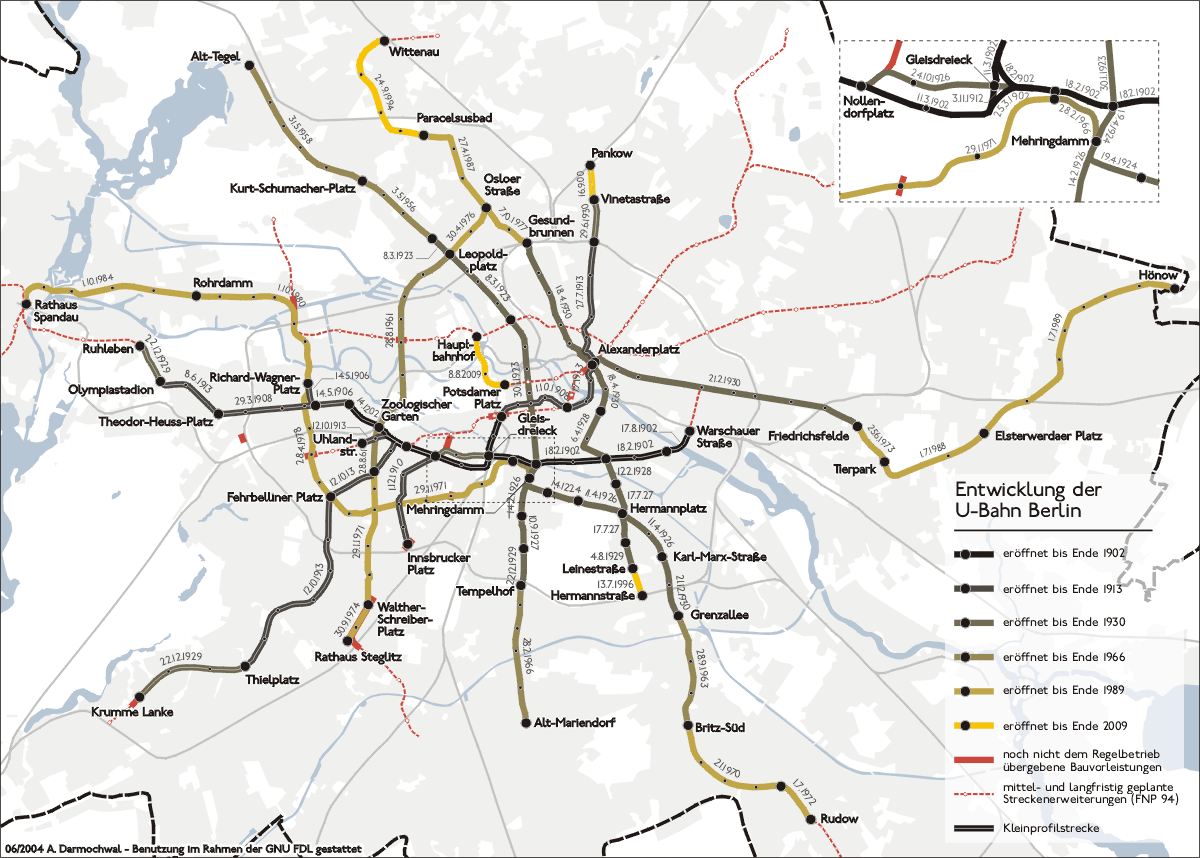
Deutsch: Karte der Entwicklung der Berliner U-Bahn English: Expansion map of the Berlin U-Bahn Русский: Схема истории развития Берлинского метрополитена |
| Date | |
| Source | Own work |
| Author | Sansculotte |
| Permission (Reusing this file) |
cc-by-sa Version 2.0 Deutsch: Quellenangabe und Beleg an sansculotte@despammed.com erbeten. English: List of references and voucher please send to sansculotte@despammed.com Русский: Замечания по схеме просьба присылать автору: sansculotte@despammed.com |
Licensing
[edit]
This file is licensed under the Creative Commons Attribution-Share Alike 2.0 Generic license.
- You are free:
- to share – to copy, distribute and transmit the work
- to remix – to adapt the work
- Under the following conditions:
- attribution – You must give appropriate credit, provide a link to the license, and indicate if changes were made. You may do so in any reasonable manner, but not in any way that suggests the licensor endorses you or your use.
- share alike – If you remix, transform, or build upon the material, you must distribute your contributions under the same or compatible license as the original.
File history
Click on a date/time to view the file as it appeared at that time.
| Date/Time | Thumbnail | Dimensions | User | Comment | |
|---|---|---|---|---|---|
| current | 17:36, 29 July 2014 | | 1,200 × 858 (314 KB) | Kopiersperre (talk | contribs) | optipng |
| 18:51, 13 August 2009 |  | 1,200 × 858 (520 KB) | Chumwa (talk | contribs) | Lehrter Bahnhof → Hauptbahnhof, zwei geplante Streckn ergänzt | |
| 17:49, 10 August 2009 |  | 1,200 × 858 (569 KB) | Chumwa (talk | contribs) | U55 ist jetzt in Betrieb | |
| 19:10, 20 August 2005 |  | 1,200 × 858 (231 KB) | Jcornelius (talk | contribs) | {{English}} * Description: Expansion map of the Berlin U-Bahn * Author: Sansculotte * Date: June 2004 * License: cc-by-sa Version 2.0 * '''List of references and voucher please send to [mailto:sansculotte@despammed.com san |
You cannot overwrite this file.
File usage on Commons
The following 3 pages use this file:
File usage on other wikis
The following other wikis use this file:
- Usage on de.wikipedia.org
- Usage on en.wikipedia.org
- Usage on es.wikipedia.org
- Usage on et.wikipedia.org
- Usage on fi.wikipedia.org
- Usage on he.wikipedia.org
- Usage on hr.wikipedia.org
- Usage on hu.wikipedia.org
- Usage on id.wikipedia.org
- Usage on it.wikipedia.org
- Usage on ko.wikipedia.org
- Usage on ku.wikipedia.org
- Usage on lmo.wikipedia.org
- Usage on nl.wikipedia.org
- Usage on no.wikipedia.org
- Usage on pt.wikipedia.org
- Usage on ru.wikipedia.org
- Usage on sv.wikipedia.org
- Usage on uz.wikipedia.org
- Usage on www.wikidata.org