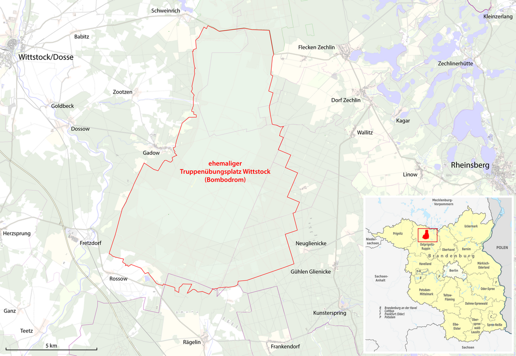
File:Karte des ehemaligen Truppenübungsplatz Wittstock (Bombodrom).png
Jump to navigation
Jump to search

Size of this preview: 800 × 552 pixels. Other resolutions: 320 × 221 pixels | 640 × 442 pixels | 1,024 × 707 pixels | 1,280 × 883 pixels | 2,560 × 1,767 pixels | 5,064 × 3,495 pixels.
Original file (5,064 × 3,495 pixels, file size: 4.11 MB, MIME type: image/png)
Captions
Captions
Add a one-line explanation of what this file represents
| Description |
|
| Date | see file history |
| Source |
Own work, using
|
| Author | Maximilian Dörrbecker (Chumwa) |
| Permission (Reusing this file) |
All OpenStreetMap data and maps are Creative Commons "CC-BY-SA 2.0" licensed This file is licensed under the Creative Commons Attribution-Share Alike 2.0 Generic license.
|
File history
Click on a date/time to view the file as it appeared at that time.
| Date/Time | Thumbnail | Dimensions | User | Comment | |
|---|---|---|---|---|---|
| current | 17:31, 31 May 2015 | | 5,064 × 3,495 (4.11 MB) | Chumwa (talk | contribs) | {{Information |Description= *{{de|Lagekarte des ehemaligen Truppenübungsplatz Wittstock/Dosse (Bombodrom)}} |Author=Maximilian Dörrbecker (Chumwa) |Source={{own}}, using * OpenStreetMap data for the backgro... |
You cannot overwrite this file.
File usage on Commons
The following 2 pages use this file:
File usage on other wikis
The following other wikis use this file:
- Usage on de.wikipedia.org
- Usage on www.wikidata.org
.png&oldid=476009849)