File:Karte des Städtischen Centralvieh- und Schlachthofs in Berlin.png
Jump to navigation
Jump to search

Size of this preview: 800 × 554 pixels. Other resolutions: 320 × 222 pixels | 640 × 444 pixels | 1,024 × 710 pixels | 1,280 × 887 pixels | 1,779 × 1,233 pixels.
Original file (1,779 × 1,233 pixels, file size: 843 KB, MIME type: image/png)
Captions
Captions
Add a one-line explanation of what this file represents
| Description |
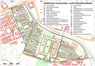
Deutsch: Karte des Städtischen Centralvieh- und Schlachthofs in Berlin. Die historische Bebauung (Zustand 1881-1945, teilweise bis 1990) ist in schwarz über der aktuellen Bebauung 2009 dargestellt. |
| Date | see file history |
| Source |
Own work, using
|
| Creator | |
| Permission (Reusing this file) |
All OpenStreetMap data and maps are Creative Commons "CC-BY-SA 2.0" licensed This file is licensed under the Creative Commons Attribution-Share Alike 2.0 Generic license.
|
| Georeferencing | If inappropriate please set warp_status = skip to hide. |
File history
Click on a date/time to view the file as it appeared at that time.
| Date/Time | Thumbnail | Dimensions | User | Comment | |
|---|---|---|---|---|---|
| current | 13:06, 14 August 2009 | | 1,779 × 1,233 (843 KB) | Chumwa (talk | contribs) | aktuelle Bebauung ergänzt |
| 18:18, 10 August 2009 |  | 1,779 × 1,233 (836 KB) | Chumwa (talk | contribs) | {{Information |Description={{de|Karte des Städtischen Centralvieh- und Schlachthofs in Berlin (Zustand 1881-1990 in schwarz über der aktuellen Bebauung 2009)}} |Author=Maximilian Dörrbecker (Chumwa) |Source={{own |
You cannot overwrite this file.
File usage on Commons
The following 2 pages use this file:
File usage on other wikis
The following other wikis use this file: