File:Karte Weiltalsperre.png
Jump to navigation
Jump to search

Size of this preview: 598 × 600 pixels. Other resolutions: 239 × 240 pixels | 479 × 480 pixels | 766 × 768 pixels | 1,177 × 1,180 pixels.
Original file (1,177 × 1,180 pixels, file size: 375 KB, MIME type: image/png)
Captions
Captions
Add a one-line explanation of what this file represents
Summary
[edit]
| Description |
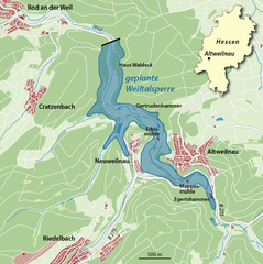
Deutsch: Lage der ehemals geplanten Weiltalsperre
English: Map of unbuilt reservoir Weiltalsperre |
||||||||||||
| Date | |||||||||||||
| Source |
Own work |
||||||||||||
| Author | NordNordWest | ||||||||||||
| Permission (Reusing this file) |
|

|
This map has been made or improved in the German Kartenwerkstatt (Map Lab). You can propose maps to improve as well.
|
File history
Click on a date/time to view the file as it appeared at that time.
| Date/Time | Thumbnail | Dimensions | User | Comment | |
|---|---|---|---|---|---|
| current | 09:50, 11 February 2015 | | 1,177 × 1,180 (375 KB) | NordNordWest (talk | contribs) | corr |
| 18:03, 10 February 2015 |  | 1,177 × 1,180 (375 KB) | NordNordWest (talk | contribs) | upd | |
| 14:38, 10 February 2015 |  | 1,177 × 1,180 (374 KB) | NordNordWest (talk | contribs) | upd | |
| 18:16, 6 February 2015 |  | 1,177 × 1,180 (371 KB) | NordNordWest (talk | contribs) | == {{int:filedesc}} == {{Information |Description= {{de|1=Lage der ehemals geplanten Weiltalsperre}} {{en|1=Map of unbuilt reservoir Weiltalsperre}} |Source={{Own}} |Date={{Date|2015|02|06}} |Author={{U|NordNordWest}} |Permission=... |
You cannot overwrite this file.
File usage on Commons
The following page uses this file:
File usage on other wikis
The following other wikis use this file:
- Usage on de.wikipedia.org