File:Karte Volt Europa.svg
Jump to navigation
Jump to search

Size of this PNG preview of this SVG file: 512 × 392 pixels. Other resolutions: 314 × 240 pixels | 627 × 480 pixels | 1,003 × 768 pixels | 1,280 × 980 pixels | 2,560 × 1,960 pixels.
Original file (SVG file, nominally 512 × 392 pixels, file size: 466 KB)
Captions
Captions
Add a one-line explanation of what this file represents
Any autoconfirmed user can overwrite this file from the same source. Please ensure that overwrites comply with the guideline.
Summary
[edit]
| Description |
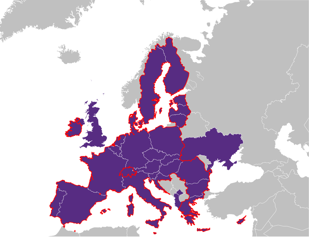
Deutsch: Mitgliedsverbände von Volt Europa (dunkelviolett) und assoziierten Parteien (hellviolett). Die Grenzen der Europäischen Union sind rot dargestellt.
English: National sections of Volt Europa (dark violet) and associated parties (light violet). The borders of the European Union are shown in red. |
| Date | |
| Source | Own work based on: EU-candidate countries map.svg by Kolja21 |
| Author | NordNordWest |

|
This map has been made or improved in the German Kartenwerkstatt (Map Lab). You can propose maps to improve as well.
|
Licensing
[edit]
I, the copyright holder of this work, hereby publish it under the following license:
| This file is made available under the Creative Commons CC0 1.0 Universal Public Domain Dedication. | |
| The person who associated a work with this deed has dedicated the work to the public domain by waiving all of their rights to the work worldwide under copyright law, including all related and neighboring rights, to the extent allowed by law. You can copy, modify, distribute and perform the work, even for commercial purposes, all without asking permission.
|
File history
Click on a date/time to view the file as it appeared at that time.
| Date/Time | Thumbnail | Dimensions | User | Comment | |
|---|---|---|---|---|---|
| current | 17:43, 31 July 2024 | | 512 × 392 (466 KB) | Larcorba (talk | contribs) | Kosovo chapter was added in July (https://www.facebook.com/voltkosovo/), accidentally lost Ukraine (re-added!) |
| 17:39, 31 July 2024 |  | 512 × 392 (466 KB) | Larcorba (talk | contribs) | Kosovo chapter was added in July (https://www.facebook.com/voltkosovo/) | |
| 17:22, 28 July 2022 |  | 680 × 520 (366 KB) | WikiBunny2K1 (talk | contribs) | Ukraine chapter recently launched ([https://twitter.com/VoltUkraine/status/1552335259039047681 Source))] | |
| 15:01, 1 April 2022 |  | 680 × 520 (368 KB) | NordNordWest (talk | contribs) | c | |
| 16:32, 21 February 2022 |  | 680 × 520 (370 KB) | NordNordWest (talk | contribs) | c | |
| 18:36, 20 February 2022 |  | 680 × 520 (371 KB) | NordNordWest (talk | contribs) | == {{int:filedesc}} == {{Information |description= {{de|1=Mitgliedsländer von Volt Europa (dunkelviolett), assoziiert (hellviolett), Europäische Union rot umrandet}} {{en|1=National sections of Volt Europa (dark violett), associated (light violett), European Union red border}} |source={{Own based|EU-candidate_countries_map.svg|by=Kolja21}} |date={{Date|2022|02|20}} |author={{U|NordNordWest}} |permission= |other_versions= }} {{Kartenwerkstatt}} == {{int:license-header}} == {{self|Cc-zero}} [... |
You cannot overwrite this file.
File usage on Commons
The following page uses this file:
File usage on other wikis
The following other wikis use this file:
- Usage on ca.wikipedia.org
- Usage on de.wikipedia.org
- Usage on en.wikipedia.org
- Usage on es.wikipedia.org
- Usage on fa.wikipedia.org
- Usage on it.wikipedia.org
- Usage on lb.wikipedia.org
- Usage on mk.wikipedia.org
- Usage on mt.wikipedia.org
- Usage on nl.wikipedia.org
- Usage on pl.wikipedia.org
- Usage on simple.wikipedia.org
- Usage on sq.wikipedia.org
- Usage on tr.wikipedia.org
View more global usage of this file.