File:Karte Taubertalbahn.svg
Jump to navigation
Jump to search

Size of this PNG preview of this SVG file: 400 × 600 pixels. Other resolutions: 160 × 240 pixels | 320 × 480 pixels | 512 × 768 pixels | 683 × 1,024 pixels | 1,366 × 2,048 pixels | 667 × 1,000 pixels.
Original file (SVG file, nominally 667 × 1,000 pixels, file size: 304 KB)
Captions
Captions
Add a one-line explanation of what this file represents
Summary
[edit]
| Description |
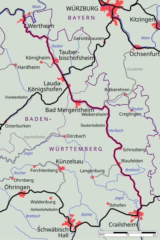
Deutsch: Karte der Taubertalbahn. Weitere Hinweise siehe hier.
English: map of Tauber Railway. please see de:User:Kjunix/BahnNWB for comments. |
| Date | |
| Source | derived from Image:Eisenbahnstrecken noerdliches Baden-Wuerttemberg.svg |
| Author | kjunix and Ssch |
Licensing
[edit]
I, the copyright holder of this work, hereby publish it under the following licenses:

|
Permission is granted to copy, distribute and/or modify this document under the terms of the GNU Free Documentation License, Version 1.2 or any later version published by the Free Software Foundation; with no Invariant Sections, no Front-Cover Texts, and no Back-Cover Texts. A copy of the license is included in the section entitled GNU Free Documentation License. |
| This file is licensed under the Creative Commons Attribution-Share Alike 3.0 Unported license. | ||
| ||
| This licensing tag was added to this file as part of the GFDL licensing update. |
This file is licensed under the Creative Commons Attribution-Share Alike 2.0 Germany license.
- You are free:
- to share – to copy, distribute and transmit the work
- to remix – to adapt the work
- Under the following conditions:
- attribution – You must give appropriate credit, provide a link to the license, and indicate if changes were made. You may do so in any reasonable manner, but not in any way that suggests the licensor endorses you or your use.
- share alike – If you remix, transform, or build upon the material, you must distribute your contributions under the same or compatible license as the original.

You may select the license of your choice.
File history
Click on a date/time to view the file as it appeared at that time.
| Date/Time | Thumbnail | Dimensions | User | Comment | |
|---|---|---|---|---|---|
| current | 12:18, 17 February 2007 | | 667 × 1,000 (304 KB) | Kjunix (talk | contribs) | some minor enhancements |
| 19:11, 15 February 2007 |  | 667 × 1,000 (301 KB) | Kjunix (talk | contribs) | new design | |
| 12:18, 22 January 2007 |  | 667 × 1,000 (280 KB) | Kjunix (talk | contribs) | == Description == {{Information| |Description = *{{de|Karte der Taubertalbahn. Selbst gezeichnet, abgeleitet von Image:Eisenbahnstrecken noerdliches Baden-Wuerttemberg.svg. Weitere Hinweise siehe hier.}} *{{en|map of Taube |
You cannot overwrite this file.
File usage on Commons
The following page uses this file:
File usage on other wikis
The following other wikis use this file:
- Usage on de.wikipedia.org
- Usage on www.wikidata.org