File:Karte Tagebau Garzweiler deutsch 2023.png
Jump to navigation
Jump to search

Size of this preview: 800 × 415 pixels. Other resolutions: 320 × 166 pixels | 640 × 332 pixels | 1,024 × 531 pixels | 1,280 × 664 pixels | 2,560 × 1,327 pixels | 6,024 × 3,123 pixels.
Original file (6,024 × 3,123 pixels, file size: 1.4 MB, MIME type: image/png)
Captions
Captions
Add a one-line explanation of what this file represents

|
This map image could be re-created using vector graphics as an SVG file. This has several advantages; see Commons:Media for cleanup for more information. If an SVG form of this image is available, please upload it and afterwards replace this template with
{{vector version available|new image name}}.
It is recommended to name the SVG file “Karte Tagebau Garzweiler deutsch 2023.svg”—then the template Vector version available (or Vva) does not need the new image name parameter. |
Summary
[edit]
| Description |
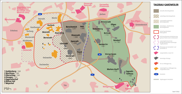
Deutsch: Karte des Tagebaus Garzweiler im Rheinischen Braunkohlerevier, Nordrhein-Westfalen, Deutschland.
English: Map of the Garzweiler surface mine in the Rhenish lignite mining area, North Rhine-Westphalia, Germany.
Français : Carte de la mine à ciel ouvert de Garzweiler dans la zone d'extraction de lignite rhénane, Rhénanie-du-Nord-Westphalie, Allemagne.
Nederlands: Kaart van de dagbouwmijn Garzweiler in het Rijnlandse bruinkoolmijngebied, Noordrijn-Westfalen, Duitsland. |
| Date | |
| Source | https://commons.wikimedia.org/wiki/File:Karte_Tagebau_Garzweiler_deutsch_2020.png |
| Author | RurKreisJülich |
| Permission (Reusing this file) |
Die Regeln von @Arne Müseler einhalten |
Licensing
[edit]
I, the copyright holder of this work, hereby publish it under the following license:
| This file is made available under the Creative Commons CC0 1.0 Universal Public Domain Dedication. | |
| The person who associated a work with this deed has dedicated the work to the public domain by waiving all of their rights to the work worldwide under copyright law, including all related and neighboring rights, to the extent allowed by law. You can copy, modify, distribute and perform the work, even for commercial purposes, all without asking permission.
|
File history
Click on a date/time to view the file as it appeared at that time.
| Date/Time | Thumbnail | Dimensions | User | Comment | |
|---|---|---|---|---|---|
| current | 11:31, 21 January 2023 | | 6,024 × 3,123 (1.4 MB) | RurJülicher (talk | contribs) | Veränderung des Abbaugebiets Garzweiler |
| 13:02, 30 December 2022 |  | 6,024 × 3,123 (1.39 MB) | RurJülicher (talk | contribs) | {{Information |Description=Karte Tagebau Garzweiler |Source={{own}} |Date=30.12.2022 |Author= RurKreisJülich |Permission=jeder darf es frei benutzen }} |
You cannot overwrite this file.
File usage on Commons
The following page uses this file:
File usage on other wikis
The following other wikis use this file:
- Usage on de.wikipedia.org
- Erkelenz
- Bundesautobahn 44
- Bundesautobahn 61
- Devastierung
- Tagebau Garzweiler
- Holzweiler (Erkelenz)
- Keyenberg
- Immerath (Erkelenz)
- Borschemich
- Kuckum
- Berverath
- Alt-Otzenrath
- Alt-Spenrath
- Alt-Holz
- Pesch (Erkelenz)
- Lützerath
- Oberwestrich
- Unterwestrich
- Immerath (neu)
- Otzenrath
- Spenrath
- Holz (Jüchen)
- Eggeratherhof
- Autobahnkreuz Holz
- Autobahndreieck Jackerath
- Keyenberg (neu)
- Kuckum (neu)
- Berverath (neu)
- Roitzerhof
- Weyerhof (Erkelenz)
- Unterwestrich (neu)
- Oberwestrich (neu)
- Bergbau im Rhein-Kreis Neuss
- Bergbau in Mönchengladbach
- Usage on en.wikipedia.org
- Usage on ja.wikipedia.org
- Usage on li.wikipedia.org
- Usage on nl.wikipedia.org